With the Fremantle Traffic Bridge set to close in February 2026 for up to 12 months, significant traffic changes are already being implemented along Stirling Highway to be ready for the closure. These are being done after hours to avoid peak traffic times.
Once completed and operational, when you’re driving north from North Fremantle, or south from the High Road roundabout along Stirling Highway toward North Freo, here’s what you need to know about where you can and can’t turn.
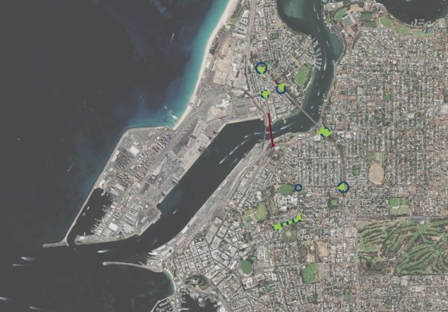
The Big Picture
When the bridge closes, around 24,000 vehicles per day will need to find alternative routes (or other ways to travel), with most redirected to Stirling Highway and the Stirling Bridge. To keep traffic flowing, Main Roads WA has removed several turning movements and reconfigured key intersections.
Heading South on Stirling Highway from North Freo: What’s Changed
* At Queen Victoria Street, North Freo: Where there are presently two lanes turning right as you approach Queen Victoria Street, after the bridge closure there will only be one lane for turning right. Road users will only choose to use the right lane if they want to access the Queen Victoria Street and Tydeman Road/Port area, or make their way to Port and Leighton Beaches (and Sandtrax!) and the Rotto ferry terminal.
* At Tydeman Road: NO right turn from Stirling Highway into Tydeman Road (removed). Alternative: Use Queen Victoria Street from Stirling Highway (as just described) to access Tydeman Road or head to the coast.
*At Canning Highway: once over the Stirling Bridge you CAN turn left from Stirling Highway onto Canning Highway (via give way). But note: there will be no general east-west traffic on Canning Highway at the Stirling Highway intersection – only Transperth buses and emergency services can travel east-west.
*At Marmion Street: From Stirling Highway you CAN turn left as presently, and CAN still turn right into Marmion Street, ut the right turn is on a dedicated green arrow with an additional 200-metre extended turning pocket now in place.
Driving north from High Street Roundabout on Stirling Highway: What’s Changed
*At Marmion Street: NO right turn from Stirling Highway to Marmion Street eastbound (removed). Alternative: Given that you can’t turn right at Marmion Street or at Canning Highway, if you want to get to East Fremantle or further east, you can either drive east on High Street from Freo or east along Marmion Street from East Street, and then take roads like Carrington Street or Petra Street, to get to your destination. This is going to confuse folk for a while.
*At Canning Highway: NO right turn from Stirling Highway to Canning Highway eastbound (removed).
*But note, if you have come from Freo along Canning Highway, you CAN make a left turn from Canning Highway onto Stirling Bridge/Stirling Highway, which is being upgraded to two signalised lanes going north. (But you can’t drive straight through on Canning Highway – only buses and emergency services can do that).
*At John Street: Driving along Stirling Highway northbound, once over the Stirling Bridge, you CAN turn right onto John Street (a dedicated green arrow will be provided for improved safety).
East-West on Canning Highway through Stirling Highway Intersection
Reiterating, while Canning Highway is open generally, it’s when you get to Stirling Highway at the southern end of Stirling Bridge that things change. You can’t drive straight through as now. Only buses and emergency vehicles can drive though.
So, when Canning Highway traffic reaches the intersection, if coming from Freo, it must turn in a northbound direction over Stirling Bridge. There will be two lanes turning left.
If coming from East Freo turn left to access Fremantle via Stirling Highway, or turn right at the Stirling Bridge to go north.
Why These Changes?
These modifications prioritise north-south traffic flow on Stirling Highway to prevent gridlock when the bridge closes. Main Roads WA explained that the removed right turns had relatively low traffic volumes compared to the main north-south movements, and eliminating them reduces competing traffic phases at busy intersections. This aims to help keep Stirling Highway flowing.
What Can You Do?
Main Roads encourages drivers to:
– Plan alternative routes before the February closure
– Consider travelling outside peak hours (including considering different working hours)
– Explore public transport options (additional services will be added) or active transport
– Share rides where possible
– Allow extra travel time.
The road network will be monitored in real-time during the closure, with additional traffic cameras and signal modifications to manage flow as efficiently as possible. To learn more about Road Network Operations Centre operation, read a Factsheet here or watch a quick video here.
For more detailed information, including interactive maps showing all network changes, visit the Main Roads WA Swan River Crossings project website here.
By Michael Barker, Editor, Fremantle Shipping News, with thanks to Lara Goetz and Carolyn Walker
~ If you’d like to COMMENT on this or any of our stories, don’t hesitate to email our Editor.
~ WHILE YOU’RE HERE –
PLEASE HELP US TO GROW FREMANTLE SHIPPING NEWS
FSN is a reader-supported, volunteer-assisted online magazine all about Fremantle. Thanks for helping to keep FSN keeping on!
