The street names of Fremantle, like the street names of villages, towns, cities and regions everywhere, can quickly immerse you in the history of the place.
But street names often contain silences and don’t always tell you the whole story.
Fremantle is a case in point. You’d be forgiven – as an uniformed visitor – based just on the street names, to think Freo was never occupied by the Whadjuk people of the Noongar Nation for tens of thousands of years before the British set up the Swan River Colony here in 1829. But of course they were here and they did occupy the place. And they are still here. The Shipping News is pleased to acknowledge Fremantle is part of the traditional territory of the Whadjuk.
On 29 May 1931, just over a hundred years after the establishment of the British Swan River Colony and just less than a hundred years ago, Miss Kate Caldwell presented a paper on the derivation of the names of streets in Fremantle to the WA Historical Society. Her work was also serialised in one of the Fremantle papers of the day, the Fremantle Advocate. No doubt it was greeted with as much interest then as it still is today.
When you pore over Freo’s older street names you learn snippets of British history and much about Fremantle’s British settler history from 1829 onwards, but – as suggested – precious little about earlier or even contemporary Indigenous people and their history. Of course, this is simply an example of how history depends on who is recording it, and why.
Things are however changing. For example, Walyalup, the Whadjuk Noongar name for the Fremantle area, is now becoming better known around the City.
Our aim is to produce a survey of all the current streets of the City of Fremantle with the derivations of their names.
In some cases we will list older street names that are no longer in use.
Our survey is based on Miss Caldwell’s epic 1931 work and more recent work by the Fremantle History Centre and of Garry Gillard who compiles he invaluable resource, Fremantle Stuff.
We encourage you, our readers, to email us additions and corrections.
The ‘1833 survey’ and the ‘1844 survey’ references in some entries are to the first town plans for Fremantle prepared the Surveyor-General of the Colony, John Septimus Roe, and his Assistant Chauncy, which we reproduce here, with thanks to the WA State Records Office.
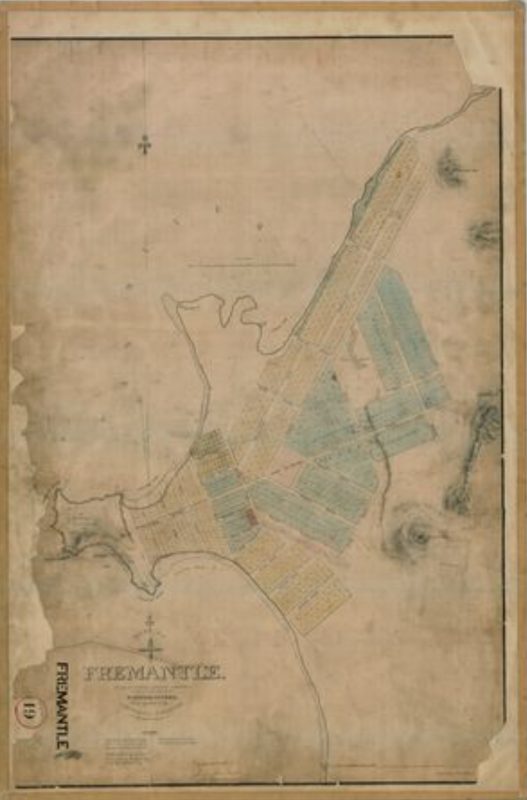
1833 survey of Fremantle
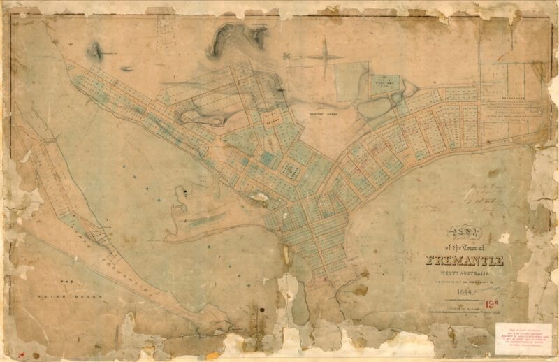
1844 survey of Fremantle
Fremantle’s streets today are, of course, far more extensive than in these very early surveys. There have also been many additions, as well as some changes, since Miss Caldwell completed her work in 1931. Not the least of which, is a street name change in her honour!
When you sing you begin with Do, Re, Me. In this first post on Freo’s street names, we will begin with with A, B, C.
Please note that when you read the entries below, the information drawn from the Fremantle History Centre work is marked ‘FHC’, that drawn from Miss Caldwell’s work is marked ‘KC’ and that from Fremantle Stuff is marked ‘FS’.
FREMANTLE STREET NAMES A-C
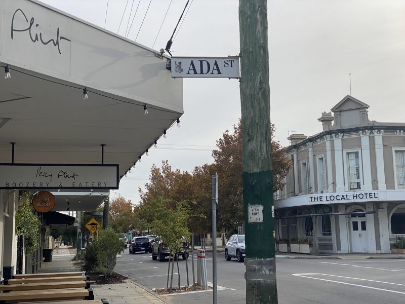
Ada Street, South Fremantle
FHC –
KC –
FS – Origin unknown, but Louisa and Florence (now King William) Streets, were named after daughters of shipbuilder Frederick Jones, so perhaps Ada and Rose Streets (all four are in the same ‘daughters’ group) were also named for someone’s daughters. There is a brothel in South Terrace between the last two streets (which was) called Ada Rose.
Adams Street, O’Connor
FHC –
KC –
FS – No information. One would like to think it is in memory of Waterloo veteran William Adams and/or his wife Elizabeth. Or both.
[Editor – information required please.]
Adcock Way, Fremantle.
FHC – after Frank Henry Burton Adcock ( – 1915) and Fredrick Brenchley Adcock ( – 1915). The Adcock brothers lived on Solomon Street, Fremantle. They were both privates in the 11th Battalion of the AIF during WWI. Frank and Frederick were both killed in action at the landing at Gallipoli on the 25th of April 1915, aged 21 and 24 years.
FS – Named for two brothers who lived in Solomon Street and died at Gallipoli 25 April 1915: Frank Henry Burton Adcock, and Fredrick Brenchley Adcock.
Adelaide Street, Fremantle
FHC – after Adelaide of Saxe-Meiningen, queen consort of King William IV (1830- 1837). Appears in the survey of 1833.
KC – Adelaide – Queen Adelaide, consort of William IV, after whom the city of Adelaide was later named. This is one of the earliest streets, appearing in the survey of 1833.
FS – Surveyed 1833. Adelaide Terrace Perth was also named for William IV’s queen. And so was the capital of South Australia.
Agnes Street, Beaconsfield
[Editor – information required please.]
Ainslie Road, North Fremantle
[Editor – information required please.]
Alexander Road, Fremantle
FHC – after Lawrence Alexander who was Mayor of the Municipality of Fremantle, 1901-02. Originally Hampton Street until 1901-02, then named Alexander Road, and renamed Wray Avenue in 1923 after W.E. Wray.
KC –
FS – was originally Hampton Street (presumably after the unpopular 1862-68 Governor John Stephen Hampton) until 1901-2 but was renamed this, and then became Wray Avenue, q.v., in 1923, after W.E. Wray. Lawrence Alexander was Mayor 1901-2.
Alice Avenue, South Fremantle
FHC – after Alice Pearse who was one of the original land owners in that street. This street no longer exists; it previously ran north from Island Road.
KC –
FS – was named for Alice Pearse, one of the original landowners in that street. This street no longer exists; it previously ran north in South Fremantle from Island Road, which also no longer exists.
Alfred Road, North Fremantle
[Editor – information required please.]
Alma Street, Fremantle
FHC – after The Battle of Alma (1854, Crimean War). Name appears after 1855; the Convict Establishment settled with guards who would have served during the Crimean War.
KC – Alma – This street does not appear on the survey of the town in 1844, and did not come into existence until after the convict period, when the Convict Establishment (1855) and the Comptroller’s residence, The Knowle, were built. Many of the pensioners who came out as guards on the convict ships would no doubt have seen military service in the Crimea, and from the Battle of Alma in that campaign (1854) the street would derive its name. The Knowle, which took up the greater portion of the northern side of the street, was later converted into an Old Men’s Depot, and when it was afterwards taken over as the Fremantle Public Hospital, the old men were removed to the Barracks (now the Immigrants’ Home) in South Terrace. Before October 25, 1897, when the first board was appointed, all that was in existence in Fremantle was a casualty hospital, the staff comprising a sister-in charge, two servants, and an orderly. In the report for the year 1895 the total of patients was 156, with a daily average of 18, and 17 deaths in the period under review. The hospital was under the supervision of Dr AR Waylen, who is shown in the blue book as having paid it two surprise visits in 1894. He joined the service in March, 1859, and was appointed Colonial Surgeon for the Colony in August, 1872.
FS – Not named for a woman but after the Battle of Alma (1854) in the Crimean War, the street having been made after that date, and many warders having fought in the Crimea. The Alma is a small river in Crimea; it flows into the Black Sea. Alma Street Cemetery is the name of the first Fremantle cemetery. Name appears 1855.
Ameling Rise, Fremantle
FHC – after Anne Hilda Ameling. Ameling was the owner of the whole parcel of land before subdivision.
FS – Anne Hilda Ameling was the owner of the whole parcel of land there before subdivision.
Amherst Street, Fremantle & White Gum Valley
FHC – Josceline George Herbert Amherst (1846 – 1900). Amherst was a barrister, cricketer, politician, and businessman. He was the Private Secretary to Governor of Western Australia Frederick Broome, 1885 to 1887. He was a member of Western Australia’s first Legislative Council, nominated by Governor Broome in 1890.
KC – Amherst – The Hon JGH Amherst was private secretary to the Governor, Sir Frederick Napier Broome, 1885-89. [Editor’s note. The correct years appear to be 1883-89]
FS – Governor Broome’s secretary 1885-89 was J.G.H. Amherst.
Anglesea Point, Fremantle
FHC – after Marquis of Anglesea (ship). The Marquis of Anglesea was wrecked on that spot in 1829.
Annie Street, Beaconsfield
FHC – after Anne “Annie” Mary Healey (1863 – 1932). Annie was the daughter of John Healy, owner of Winterfold Estate. This road was formerly in Hamilton Hill and is now in Beaconsfield.
FS – Anne ‘Annie’ Mary Healey (1863-1932) was the daughter of John Healy, owner of Winterfold Estate. This road was formerly in Hamilton Hill and is now in Beaconsfield.
Antrim Lane, Fremantle
FHC – after County Antrim, Ireland. Antrim is in the same country as the birthplace of C Y O’Connor.
Arthur Head, Fremantle
FHC – after Sir George Arthur, 1st Baronet (1784 – 1854). The name was chosen by Captain James Stirling during his 1827 expedition. Arthur was the 4th Lieutenant Governor of Van Diemen’s Land (Tasmania) and had shown Stirling’s party much hospitality in Hobart. Also known as Arthur’s Head.
Arundel Street, Fremantle
FHC – after Arundel (UK Parliament constituency). Edward George Fitzalan-Howard, 1st Baron Howard of Glossop was MP for Arundel in England from 1852 to 1868. Howard Street runs parallel to Arundel Street, thus making the connection.
KC – Arundel – Edward George Fitzalan Howard, first Baron Howard of Glossop (1818-83), second son of the 13th Duke of Norfolk, was MP for Arundel in England from 1853 to 1868, losing his seat in the general election that year. Howard Street adjoins Arundel Street, thus making the connection. [Editor’s note. It might also have been noted that Norfolk Street is just two streets north of Arundel.] Between this street and Howard-street was situated the old water jetty. The Fremantle sea baths which were demolished in the early part of this century were built over the spot. Eastward of the jetty was a well and a pump house. The water was carried by a pipe to the jetty where it was put into casks and shipped on lighters to be transferred to overseas vessels anchored in the roads.
FS – One of the ‘lord streets’ (my term). Baron Howard (of the adjacent street) was 1852-68 the member for Arundel, West Sussex (pronounced there with the accent on the first syllable, not as in WA, where the accent is usually on the second).
Ashburton Terrace, Fremantle
FHC – Harry James William Higham was the original owner of this property. He settled in the Ashburton with his wife and children.
KC – Ashburton Terrace – The original owner of the land on which this street was made was Mr HJ Higham, and Ashburton was the name of his station in the North-West.
FS – The same name as that of H.J. Higham’s NW station. Higham owned the land where the street was made.
Attfield Lane
FHC – changed to Parmelia Street, 1935/36.
[Editor – presumable to Parmelia Street, South Fremantle.]
Attfield Street, Fremantle/South Fremantle
FHC – Dr. George Cook Attfield (1822 – 1923). Attfield was the Imperial Surgeon for the Fremantle Convict Establishment between 1857 and 1879 and he was Superintendent at Fremantle Lunatic Asylum.
KC – Attfield – Dr G Attfield was Imperial Surgeon between 1854 and 1879. He married a daughter of Surveyor-General Roe and died in England at an advanced age.
FS – was renamed Parmelia Street, qv.
Attfield Street. The Imperial Surgeon 1854-1879 was Dr G.C. Attfield. Appears 1903.
Aurora Avenue, Fremantle
FHC – Street name disappears after 1948.
FS – Gone after 1948. Location unknown. May have been one of a group of streets in South Fremantle which were planned: Austral Avenue, Island Street, Ocean Street.
Austral Avenue, Fremantle
FHC – with Aurora, Avenue, Island Street and Ocean Street disappears after 1948.
FS – See Aurora Avenue.
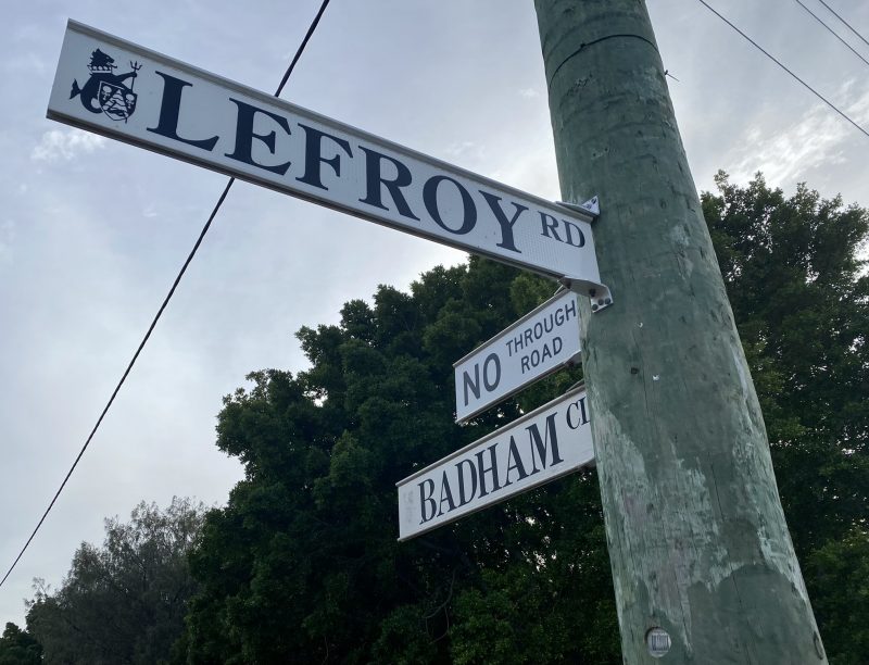
Badham Close, Beaconsfield
FHC – after Badham, a Hilton Park businessman. [Editor – more information please.]
Baird Place, Samson
FHC – Colin Baird (1954 – 1991). Baird was a chemist at Hilton Park and was Vice Patron of the Hilton Park Progress Association.
Baker Street, Fremantle
FHC – Baker Street was originally named Leah Street by Abraham Josephson and John McCleary. They were both Fremantle merchants and purchased Fremantle Lots 828, 829 and 830, on 23 March 1886 and subdivided them to create many smaller lots. Leah Street was created to provide road access to the new properties that were sold between 1886 and 1891. Changed from Leah to Baker in 1908/09.
Bannister Street, Fremantle
FHC – Captain Thomas Bannister (1799 – 1874). Captain Bannister was one of the first pioneers to be assigned a lot of land in Fremantle. He later undertook the exploration of the country between Perth and Albany and was for a time Resident Magistrate at Fremantle.
KC – Bannister – Captain T Bannister was the buyer of the first allotment in Fremantle. He was an early explorer and at one time Government Resident in the town. On December 11, 1830, he set out with Mr Smythe of the Surveyor-General’s Department, and two servants to tramp to Albany via Kelmscott. They duly arrived on February 4, 1831. Bannister, near the Williams, bears his name.
FS – named after Captain Thomas Bannister (1799-1874) who arrived aboard the Atwick in 1829 and bought one of the first four allotments sold in Fremantle in September 1829 (Hitchcock: 15). The Bannister River and town of North Bannister are also named after him.
Barfield Place, Beaconsfield
FHC – after John Henry Barfield ( – 1952). Barfield served as a private in the 11th Battalion 19th Reinforcement of the AIF during WWI. He was captured by the Germans in 1917 and remained a prisoner at Limburg an der Lahn until the war ended. Before and after the war he lived with his family in Fremantle. He road formerly in Hilton, now in Beaconsfield.
Barker Street, North Fremantle
[Editor – information required please.]
Barnett Street, Fremantle
FHC – Henry Calvert Barnett (1832 – 1897). Barnett succeeded Dr Dickey as Superintendent of Fremantle Asylum in 1872. He was Colonial Surgeon until 1895 when the office was abolished. He worked chiefly in Fremantle. His articles on “Australiana” earned him a Fellowship of the Royal Geographic Society. Barnett was a member of the first Medical Board in 1894. He resided in Quarry Street near Shuffrey.
KC – Barnett – Dr HC Barnett, whose first Government appointment was in 1868, was appointed Superintendent of the Asylum in April 1872, at a salary of £500. He was also Colonial Surgeon until 1895, when the office was abolished. At the same time he acted as District Registrar of Births. Deaths and Marriages. His private residence was on the cliff overlooking this street. Mr JK Hitchcock in the History of Fremantle, mentions the belief that was never contradicted in Fremantle, that the doctor amputated his own leg when at sea. (He had come to the Colony as a ship’s surgeon.) What he himself did tell one of his patients was that he had had an accident when kangarooing, and the limb had had to be amputated. Some time later it appeared as if the limb were becoming gangrenous. He was then at York and the only medical man in the district, and, as the case was desperate, and he knew he would not be able to take the long rough journey by road to Perth, with the help of his man, and no doubt a local anaesthetic, he was able to cut off a further portion of the leg and thus arrest the mortification.
FS – named for its most significant resident, Dr H.C. Barnett, who was Superintendent of the Asylum and then Colonial Surgeon. One of his houses (his last) has stood since 1897 overlooking Fremantle Park, at 13 Barnett Street. It is currently the residence of Robert Bodkin.
Bateman Street, Fremantle
FHC – after the Bateman Family. The Batemans arrived in 1830. John Bateman was the first Postmaster of Fremantle.
KC – Bateman – The Bateman family arrived in 1830. The firm of J and W Bateman Ltd general merchants is still in existence.
FS – The principal hardware store in Freo used to be Bateman’s, in Henry Street, the family having arrived in 1830. The Union Stores building, on the corner of High and Henry Streets was one of several owned by J&W Bateman.
Bathers Beach, Fremantle
FHC – also known as Whalers’ Beach. It was known as City Beach in 1945.
Bathers Bay, Fremantle
FHC – shown on Fremantle maps from 1829 pm.
Bayleaf, Retreat, O’Connor
FHC – after the Bayleaf tree. Exotic tree species identified and preserved on the site.
Bay Road, North Fremantle
[Editor – can’t see it on Maps. Does it still,exist? More information please.]
FS – It seems there was a Bay Road in North Fremantle, in the vicinity of Phyllis Street.
Bay Street, Fremantle
FS – Now Elder Place. Bay Street ran from Market Street to Shoal Bay (whence the name), which was a sandy bay in the Swan River at the foot of Edward Street (which is now Parry Street). Bay Street became Beach Street halfway between Point Street and Edward Street (so Elder Place is a little longer than Bay Street was). Shoal Bay no longer exists, having been filled in with the dredged soil from the Point to become part of what is now the South Wharf (Victoria Quay) of the harbour. Point Street was named for the point in the river associated with Shoal Bay – which also went by the names Ferry Point and Willis’s Point.
Bayly Street, North Fremantle
[Editor – information required please.]
Beach Street, Fremantle
FHC – Descriptive name as the street runs parallel with the shore of the Swan River.
KC – Beach – This name is self-explanatory, as the street runs parallel with the shore of the river.
FS – The ‘beach’ was the river beach. Beach Street now runs from the corner of Parry Street (the former Edward Street) to East Street, which is the boundary between Fremantle and East Fremantle. It used to start a little bit further west (of Edward/Parry Street) where it joined Bay Street (now Elder Place).
Beaconsfield (the suburb)
FHC – named after Beaconsfield, England. Appears in use from the 1880s.
Beard Street, South Fremantle
FHC – George B Beard was a Town Councillor from 1901 until 1903. Originally called Maud Street; changed in 1909-10.
KC – Beard – George Beard was a Town Councillor from 1901 to 1903.
FS – One of a great many streets named for a Town Councillor; in this case George B. Beard, 1901-1903. The street was originally called Maud Street, until 1909/10.
Bellamy Street, O’Connor
FHC – after Bellamy, a pioneer.
[Editor – more information please.]
Beazley Way, White Gum Valley
FHC – after Kim Edward Beazley, AO (1917 – 2007). Beazley was the Federal Member for Fremantle between 1945 and 1977. Former Beazley School site.
FS – Kim Edward Beazley, AO (1917-2007) was Federal Member for Fremantle 1945-1977. Former Beazley School site. Beazley himself was a student at Beaconsfield Primary School. His son Kim Beazley Junior is until 2022 governor of Western Australia, as his second compensation prize (the first was ambassador to the USA) for not becoming Australia’s best prime minister.
Bellevue Terrace, Fremantle
FHC – no information supplied.
KC – Bellevue – The origin of the street name is doubtful, but the short portion northward of Fothergill Street was originally called Higham Street, John Joseph Higham bring one of the Town Councillors. His parents arrived in the Colony in 1853 and started business at the corner of High and Pakenham Streets on the block where the Bank of Adelaide at present stands. On the father’s death Mrs M Higham built on the block at the south-west corner of High and Market Streets, the property being still known as Higham’s Buildings. Previously it had been a vacant allotment covered with rushes and pools of water, whereto the ducks of the town used to repair for refreshment, and where also small boys used to search for eggs.
FS – Probably named for the view from the northern end: Fr. belle vue = beautiful view.
Belmont Street, South Fremantle
[Editor – information required please.]
Bennewith Street, Hilton
FHC – after A A Bennewith. Bennewith was a Town Councillor from 1943 to 1958.
Berglund [reserved road name], Beaconsfield
FHC – after Andrew Olaf Berglund. Berglund sailed on the Warlock from Sweden to Melbourne in 1882. He moved to Western Australia in 1883, or 1884, where he worked on the tug boats for the Adelaide Steam Ship Company in Mouat Street, Fremantle. He lived in Beaconsfield and was buried in Fremantle Cemetery.
Bick Lane, North Fremantle
FHC – John Alfred Bick (1843 – 1916). Bick was a member of the first North Fremantle Municipal Council in 1895. He was publican of the Swan Hotel (North Fremantle) in 1888, purchased the property in 1892, and continued to operate the hotel himself until 1895. In August 1891 he purchased portions of Swan Location 130, Lots 10 and 11, with frontage to Harvest Road, North Fremantle. Lot 11 would form part of the future site of “Hillcrest” in North Fremantle. Bick was married to Harriet Caroline Bick (1842-1917). They had three children: Clara Mary, Ellen and Henry John.
FS – John Bick was the owner of the Swan Hotel. It continues Hicks Street from Pensioner Guard Road to Swan Street, which was named for Bick’s Swan Hotel on the corner of which it stood.
Bickley Close, Beaconsfield
FHC – after Wallace Bickley (1810 – 1876). Bickley was an early settler in the Swan Colony and became one of the leading merchants of Fremantle. He was also an agent for Lloyd’s of London, and a member of the WA Legislative Council from 1872 to his death.
Biddles Lane, White Gum Valley
FHC – Captain Frank Biddles (1851 – 1932). In 1914, Biddles purchased “Ivanhoe Lodge”, in Ord Street, and “Ocean View” at 134 Solomon Street, allowing the Solomon Street property to be used as a hospital for returned soldiers. Various properties around Fremantle are still owned by the Biddles Estate including “Princess Chambers” and “Biddles Building” in Market Street.
Bidmead [reserved road name]
FHC – after Stanley Mollet Bidmead (1897 – 1917). Fremantle-raised Bidmead served in WWI as a Sapper with the 4th Australian Division Signals Company of the AIF. In 1917 he died of wounds received in action at the 3rd Canadian General Hospital in Boulogne, France. Bidmead was 20 years old.
Binns Court, North Fremantle
FHC – after the Binns Family. The Binns family have lived in the same house for more than one hundred years. It is opposite where the State Engineering Works were located.
Birksgate Road, North Fremantle
FHC – Birksgate (steamship). The Birksgate was one of the first steamships to establish passenger travel between Fremantle, Albany, and other Australian ports. Name intended to commemorate vessels trading to Fremantle in the early days of the colony. A regular passenger steamship service operated between Liverpool and Fremantle by the Australind Steam Navigation Company.
Blamey Place, O’Connor
FHC – after Sir Thomas Albert Blamey (1884- 1951). Blamey was a teacher at Fremantle Boys’ School from 1903 to 1906. During WWI he rose to the rank of Brigadier General and served under Lt. General Sir John Monash. Between 1925 and 1936 he was Chief Commissioner of the Victoria Police. During WWII, in 1942, Blamey became the Commander in Chief of the Australian Military Forces. He was promoted to Field Marshall in 1950. He was honoured with several knighthoods and military awards.
Blamey Street, Beaconsfield
FHC – Changed to Caldwell Street.
Blinco Street, Fremantle
FHC – after Henry Blinco (1832 – 1907). Blinco was the first Principal Warder at Fremantle Prison, between 1892 and 1897. Previously named Moore Street; changed in 1909-10.
KC – Blinco – Henry Blinco was Chief Warder, Fremantle Prison. He was born in 1832, dying in 1907.
FS – Named for the Chief Warder of the Prison, Henry Blinco (1832-1907). Previously known as Moore Street, changed in 1909-10. Blinco Cottage in Swanbourne Street is close to the end of Blinco Street.
Boas Place, Hilton
FHC – after Harold Boas, OBE (1883 – 1980). Boas was an architect and Town Planner who was appointed by the City of Fremantle in 1947 to create a comprehensive Town Planning Scheme.
Bolt Street, Beaconsfield
FHC – after Edward Nichols Bolt? Bolt was the inspector on Fremantle Municipal Tramways and Electric Lighting Board. The street commemorates his service.
Bolton Place, Fremantle
FHC – after Isaac Bolton ( – 1912). Bolton founded the coach building company Bolton & Sons in Fremantle in 1888.
Booth Court, Samson
FHC – after the Booth Family. The Booths, George and Jessie, were livestock agents and carriers.
Bostock Street, White Gum Valley
FHC – Reverend George J. Bostock ( – 1888). Bostock came to Western Australia in 1858. He was transferred to Fremantle (1860-1875) from his first parish in Gingin. Built rooms for Young Men’s and Women’s Clubs alongside old rectory in Cantonment Street.
KC – Bostock – The Reverend GJ Bostock BA Trinity Hall, Cambridge, came to Western Australia in 1858 with Bishop Hale and other clergy. His first parish was Gingin, from where he was transferred to Fremantle in 1860. There he remained till 1875when he returned to England on account of ill-health. He became Rector of Kirby Wharfe, Yorkshire, and died there in 1888. While in Fremantle he built rooms for the Young Men’s and Women’s Clubs alongside the old rectory in Cantonment-street.
Bowen Street, O’Connor
FHC – after the Reverend Frederick Thomas Bowen. Bowen was the Rector at St Paul’s Church Beaconsfield from 1916 to 1925.
Bracks Street, North Fremantle
FHC – after Robert Bracks who was Mayor of North Fremantle for three periods – 1907-08, 1919-24, and 1931-32.
Bradbury Way, Samson
FHC – after Miles Bradbury who was a member of the Citizen Forces and a North Fremantle Council employee.
Bradley Court, Samson
[Editor – information required please.]
Brennan Street, Fremantle
FHC – after John Charles Brennan who was a Fremantle Town Councillor for two periods – 1909 – 1911 and 1913 – 1927. Formerly known as Cemetery Road because the old Alma Street Cemetery lay to the east. Name changed to Brennan Street in 1924/25.
KC – Brennan – John Charles Brennan was a Town Councillor for many years.
Briggs Court, Beaconsfield
FHC – Henry Briggs (1844 – 1919). Briggs was the first Headmaster of Fremantle Grammar School, between 1885 and 1897. He was Secretary of the Fremantle Chamber of Commerce between 1885 and 1897. [Editor – query, is he the one and the same as Sir Henry Briggs mentioned below in relation to Coral Street?]
Brockman Place, South Fremantle
FHC – Brockman Family. The Brockman family were early land owners. Edward Reveley Brockman owned land in Fremantle from 1896 to 1903. Sons, Hugh and William, owned land from 1905-1906.
Brolo Court, O’Connor
FHC – after Brolo, Italy. This street was named after the developer’s birthplace in Sicily.
Bromley Road, Hilton
FHC – Ernest Harvey Bromley (1912 – 1967). ‘Ernie’ Bromley was born in Fremantle. He became the first West Australian to play cricket for Australia in 1933. The Bromley family are a well-known Fremantle sporting family.
Broome Street, North Fremantle
FHC – after Sir Frederick Napier Broome (1842-1896), Governor of Western Australia from 1883 to 1889.
KC – Broome – Sir Frederick Napier Broome was Governor from 1885 to 1889. The town of Broome in the North-West also bears his name.
[Editor’s note. The correct years as Governor appear to be 1883-89, according to WA Government House website.]
FS – Sir Frederick Napier Broome (1842-1896) was Governor 1883-91. The NW town is named after him, and probably also the Cottesloe streets, Napier and Broome, which intersect. There was another Broome Street planned to be the eastern continuation of John/Fothergill Street, but it is now Stack Street.
Bruce Lee Oval
FHC – Bruce William Francis Lee. Lee was a member of the Fremantle City Council, 1941–1968, and Chairman of the Council’s Ovals and Parks committee.
Bruce Street, North Fremantle
FHC – after Lieutenant Colonel John Bruce (1808 – 1870). Captain John Bruce arrived in Fremantle 25th October 1850 aboard the second of the convict ships, the ‘Hashemy’, taking up the position of Staff Officer to the Enrolled Pensioner Force in WA. In 1854 Bruce was awarded the local rank of Brevet Major and succeeded Capt. Irwin as Commandant of the W.A. Military Force. He was assigned the task of forming a citizens’ volunteer force when the regular troops stationed in the colony were about to be withdrawn in 1861. He also served as Acting Governor of W.A. during February 1862 and again from November 1868 until September 1869. In the 1850’s he was granted 10 acres of land in North Fremantle to the east of Stirling Highway, which became known as “Brucetown” and was a favoured residential area in the late 1800’s. Mt Bruce is named in his honour. The name ‘Bruce Street’ identifies the road which was engulfed by the Stirling Highway extension and bridge. Changed to Stirling Hwy c. 1974
FS – named for John Bruce, the commander of the Enrolled Pensioner Guards, as it was associated with land granted him in 1851 and 1857. The same applies to John Street, North Fremantle.
Bundi Kudja, 96 Hampton Road
FHC – Bundi Kudja – a Nyoongar phrase possibly meaning ‘good child/babies’, or ‘house of good baby’.
Burford Place, North Fremantle
FHC – after W H Burford & Sons Pty Ltd which had a soap factory on site.
Burns Street, North Fremantle
FHC – after Andrew Burns who owned the six acre block this road passes through in the late 1880s.
Burt Street, Fremantle
FHC – Sir Archibald Paull Burt QC (1810 – 1879). Burt was the first Chief Justice of the Supreme Court of Western Australia, 1861 – 1879. The eastern end of Burt Street, from East Street, was previously called Finnerty Street.
KC – Burt – Sir Archibald Paull Burt, of St Kitt’s in the West Indies, succeeded Judge McFarlandin February 1861, later being appointed Chief Justice. He died in November 1879. His son, Mr. Septimus Burt, a leading lawyer In Perth, became first Attorney-General under Responsible Government, the Forrest Ministry being in power. This position carried a salary of £1000 per annum. The street being named in the ’70’s, it would no doubt be in honour of the Chief Justice.
[Editor’s note. Sir Archibald Paull Burt’s grandson, Sir Francis Burt, was later also a Chief Justice of Western Australia.]
Bushy Park
FHC – Known by this name in 1935. It is now the site of John Curtin College.
Butler [reserved road name]
FHC – G. James Butler. Butler was the first instructor of the Leighton Surf Life Saving Club from 1934-1935; he was made a Life Member of Leighton SLSC in 1940. Butler was killed during World War II (1943) in New Guinea.
Butson Street, Hilton
FHC – Butson Family. The Butson family were a Fremantle based, musically active family. Ernest E. Butson (1872–1951) was the conductor of the Fremantle Orchestral Society, 1917-1940, and a founding member of the WA Music Teachers’ Association. He served on the Association Council for three terms. His son, Ivan E. Butson (1899–1969), was Deputy Conductor of the Fremantle Orchestral Society in 1940. Butson’s daughter Ruth was the first almoner at Fremantle Hospital in the 1920s.
Butterworth Place, Beaconsfield
FHC – after Butterworth, Penang, Malaysia. Butterworth is the main town of Seberang Perai in Malaysia. Seberang Perai has been Fremantle’s Sister City since 1978.
By-The-Sea Road, Fremantle
FHC – changed to Jenkins Street in 1909/1910.
[Editors note – perhaps it should be changed back to the original pretty name!]
FS – renamed Jenkin Street 1909-10 for Rev. J.H. Jenkin of the South Fremantle Wesley Church. The church was one block from the corner of that and the Mandurah Road (now South Tce). Despite the name, as Kate Caldwell points out, it led to the sea, as opposed to going by it.
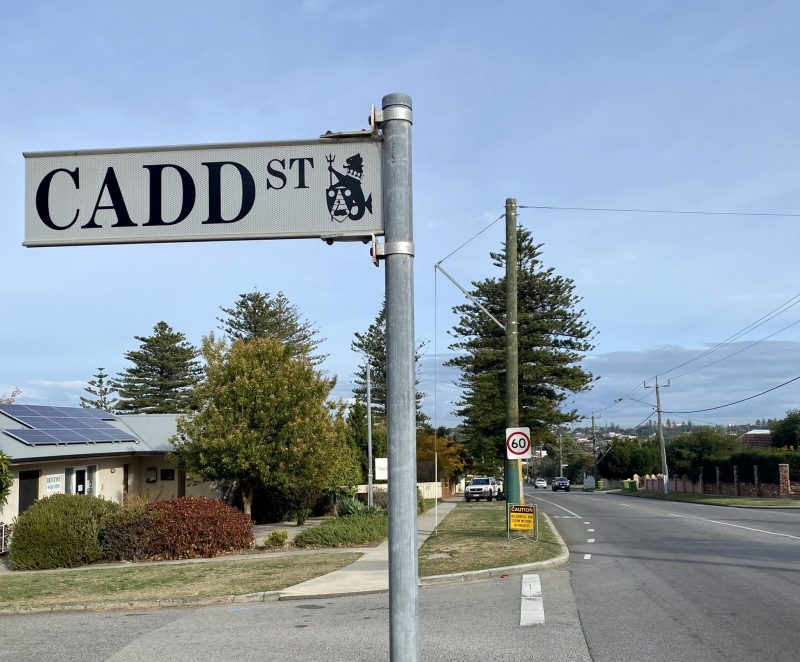
Cadd Street, Fremantle Beaconsfield
FHC – after Frank Cadd. Cadd was Mayor of Fremantle, 1904-05, and owner of F. Cadd Ltd forwarding agents.
KC – Cadd – Frank Cadd, of F Cadd Ltd (forwarding agents) was Mayor of the town in 1904-05.
FS – Frank Cadd, a merchant, was Mayor 1904-5. The Frank Cadd Building in Phillimore Street was his for a time.
Caesar Street, Beaconsfield
FHC – Frederick Caesar (1838 – 1904). Caesar arrived in Western Australia in 1871. He was the proprietor of the Emerald Isle Hotel, 1877-1889, the Pier Hotel, 1876, and the Richmond Hotel, 1884-1896.
Caldwell Street, Beaconsfield
FHC – Kate Caldwell (1889–1955). Caldwell was a founding member of the Western Australian Historical Society. She held office as Honorary Research Secretary from 1932–1947 and as Honorary Treasurer from 1948–1949. Caldwell delivered a paper to W.A. Historical Society on 29.05.1931 on the derivation of the names of streets in Fremantle. Originally named Blamey Street.
Canning Highway, East Fremantle
FHC – after George Canning (1770–1827). Canning was an eminent British statesman. He served as Secretary of State for Foreign Affairs, 1822 to 1827, and briefly as Prime Minister in 1827. Amalgamation of Canning Road, Perth- Fremantle Road, Lower Canning Road, and Fremantle Road, in 1937.
KC – Canning Highway – This road leads to the Canning River and district, which was explored by Captain Stirling and party in 1827, being named in honour of the great English statesman, Canning, who was Foreign Secretary at the time.
Cantonment Street, Fremantle
FHC – after a Cantonment – a military or police headquarters. Victoria Road and Queen Victoria Street. A detachment of the 63rd Regiment was stationed in Fremantle during the early days of the colony. The exact location of the cantonment is unknown. Cantonment Road was later named Queen Victoria Street; it ran from the bridge into the township proper. It was a continuation of Cantonment Street to Cantonment Hill. Changed to Victoria Road 1903/4 and again in 1914/15 to Queen Victoria Street.
KC – Cantonment – This street appears on Surveyor-General Roe’s very earliest map, Cantonment Road being a continuation thereof and leading to the base of what was at first called Cantonment Hill (the hill on which the Signal Station was built in 1931.) Owing to confusion, the name of Cantonment Road was changed to Queen Victoria Street in 1892. Letters are extant from the Cantonment, Fremantle, but apparently nobody at present alive knows of the exact situation of the Cantonment. As the streets were surveyed before 1833right out to the present junction of the Canning Highway, it would seem to have been somewhere in that locality.
Capo D’Orlando Drive, South Fremantle
FHC – after Capo D’Orlando, Sicily, Italy. Capo D’Orlando has been Fremantle’s Sister City since 1983. Many members of the Italian community in Fremantle, a large number of whom worked in the fishing industry, trace their origins to this locality. Named in 1993.
‘Cappuccino Strip’, Fremantle
FS – is an unofficial nickname for the section of South Terrace between Bannister and Norfolk Streets, because it was the first location where coffee was served on the footpath – at Gino’s and then Old Papa’s. The name was invented by Jeff Brockway, he told me.
Captains Lane, Fremantle
FHC – Captain Albert Ernest Trivett. Trivett was Harbour Master at Fremantle from 1945 until 1953.
Carnac Street, Fremantle
FHC – assumed after Carnac Island. This street is on an elevation from which Carnac Island can be seen. Carnac Island was named after Lt John Ruett Carnac of H.M. Frigate Success.
KC – Carnac – This street is on an elevation from which Carnac Island can be seen, and not the other islands. This may account for the name. Carnac Island (or Berthollet of the French) was named after Lieut. John Ruett Carnac of H.M. Frigate Success.
Carnac Way, Fremantle
FHC – after Carnac Island. Earliest listing in the WA Post Office Directory for 1900. South Lane in 1951/52. Named Carnac Way in 2007; previously Carnac Lane.
Carob Court, O’Connor
FHC – after he Carob tree. Exotic tree species identified and preserved on the site. Approval 1993.
Carr Street, Beaconsfield
FHC – Carr was a Town Councillor 1935-
Carrington Street, Beaconsfield/Hilton/White Gum Valley
FHC – Charles Robert Wynn-Carrington (1843 – 1928). The Earl Carrington was the 1st Marquess of Lincolnshire. He was Governor of New South Wales from 1885 to 1890.
KC – Carrington – Possibly after Earl Carrington, one-time Governor of New South Wales
Cattalini Lane, North Fremantle
FHC – after John Cattalini AO (1937 – 2005). Cattalini was a pharmacist and Mayor of Fremantle between 1984 and 1994. His High Street pharmacy is still in the family.
Cemetery Road, Fremantle
FHC – renamed Brennan Street in 1923.
Central Avenue, Beaconsfield
FHC – Central Street in former Chester Park, now Hilton Park.
KC – Central – This is the central street in what was known as Chester Park, but which is now Hilton Park. When the land was subdivided and put up for sale, a competition was held for a suitable name for the district, and this name was decided on as being most appropriate. [Editor’s note. The suburb we today refer to as Hilton Park is largely the garden suburb newly constructed after WW2.] The location would originally appear to have been granted to one McDermott. About 30 years later it came into the possession of Richard Davis, who after his arrival from England in 1853 had carried on the Half-way House at Point Walter. With the advent of steam, the boats were not using the canal, and it became silted up and the toll-house fell into disuse. He therefore removed to Bicton, and later to the Chester Park property, which he in turn sold to Chester. At the time of the subdivision it was owned by Simpson.
Chadwick Street, Hilton
FHC – Thomas Charles Chadwick was a Town Councillor, 1941-1971.
Challenger Harbour, Fremantle
FHC – after The Challenger the ship that Captain Fremantle arrived on in May 1829.
Chalmers Street, Fremantle
FHC – James Chalmers a Town Councillor for two periods, 1930-33 and 1935-1942. He established Fremantle Foundry and Engineering Co. Previously named Edmund Street North; changed in 1948.
Chamberlain Street, O’Connor
FHC – after the Chamberlain Family who were prominent Fremantle boat builders.
Charles Street, South Fremantle
[Editor – information required please.]
Chester Park
FHC – named after the Chester Family. Name changed to Hilton Park before 1930.
Chester Street, South Fremantle
FHC – after he Chester family were early settlers. Previously called William Street, Chesterfield – changed 1901-1902.
KC – Chester – This street is not in Chester Park, but in the district originally called Chrsterfield bounded by Douro Road, but it is named after the same family, who were very early settlers. At one time one of the sons carried on a butchering business in the town.
Chesterfield, South Fremantle
FHC – after the Chester family. The area including John Street, Douro Road, William Street, and Lloyd Street. Subdivided by John Chester and named Chesterfield in 1887. By 1930 the name was no longer in use.
Chivers Court & Chivers Way, Samson
FHC – after the Chivers family who were early settlers of the Hilton Park district; actively associated with the Hilton Park Progress Association.
Christina Parade, North Fremantle
[Editor – information required please.]
Chudleigh Street, Fremantle/also East Fremantle
FHC – after Chudleigh, Devonshire, England, the birthplace of R B Carter, draper and East Fremantle Town Councillor for the periods 1911-1914, 1918-1919, 1919-1925, and 1929- 1930. Formerly known as Congdon Street 1906, 1921-1922. Murphy Street 1922-23. In 1924 it was named Chudleigh Street.
Church Hill, Fremantle
FHC – Church Hill was recorded on the earliest maps of Fremantle. It was later named Scotsman’s Hill. Removed 1964.
Church Street, Fremantle
FHC – Stephen Street (later changed to Stevens Street). Named because it was bounded by the old Alma Street Cemetery which was vested in the Church of England. Formerly named Church Street; changed to Stephen Street 1930/31.
KC – Church (now Stephen [Editor’s note – Steven today]) – The old cemetery in Alma Street used to be bounded on the west and south by Church Street, so called because the cemetery was vested in the Church of England for the public benefit. The Wesley Church also owned land therein, adjoining the Scots Church grant in Little Howard Street. Within the last few years, however, the north to south portion of the street has been altered to Brennan, in honour of Joseph Brennan, who was Councillor for many years. The short section running downhill to Attfield Street still retains its original name.
Churchill Avenue, Hilton
FHC – now called Farrell Street.
Clarke Street, Hilton & O’Connor
FHC – Originally called Government Road; changed in 1922/23
KC – Clark – John McHenry Clark, a well-know draper of Fremantle, who later retired to Kojonup, where he died. He was Mayor in 1899.
[Editors note. While there is a Clarke Street in O’Connor today, there doesn’t appear to be a Clark, without the ‘e’, Street. Perhaps they are the one and the same and KC left off the ‘e’. More information please.]
Cliff Street, Fremantle
FHC – This street was built beside the face of Arthur Head cliff, which was afterwards much broken down by convict labour.
KC – Cliff – This street was built beside the face of Arthur Head cliff, which was afterwards much broken down by convict labour. One conjecture is that Arthur Head was probably named after Arthur Trimmer, a friend and fellow traveller of Sir James Stirling. The Governor granted himself five acres on the head, but the Home Authorities promptly cancelled the grant and returned the land to the Crown. In the old maps a stone jetty appears at the river end of Cliff street. Within living memory the only jetty that existed at that spot was the usual wooden structure with protecting railings, a tank being erected at the shore approach. On this tank a man was employed all day pumping water from the river (apparently windmills were non-existent). This salt water was afterwards distributed by carts on the streets. In the early days of the Colony, Phillimore street which runs from Cliff to Market streets was well below the high water mark of the river, but land was afterwards reclaimed by convict labour and the old railway station was built where the present Customs House stands, at the Cliff street corner. It would, therefore, seem that this old stone jetty was existent in pre-convict days, and was a jetty in the literal meaning of the word, stones being thrown into the water, and a roadway made on the top. Nowadays, no doubt, we would call it a mole. This jetty was the point from which goods were shipped by way of the canal to Perth. Overseas vessels would land their cargoes by lighter at the sea jetties, and the Perth merchandise would be carted across to the river, where it would be put aboard boats built something like naval cutters, which were sailed or rowed when necessity demanded. To obviate a long, circuitous route round Freshwater Bay, a passage was cut through the spit at Point Walter, and a tollhouse erected on the beach on the Fremantle side of the point. General goods were, of course, carried, but it would appear that the carriage of casks of beer is all that some of the early residents seem to remember. The method of transport was decidedly primitive. The boats were sunk to the gunwales, and the full casks were rolled into place. They would no doubt float until baling was completed, when the boats would be deemed to be well and truly loaded. If the crews were compelled to row these boats, they must surely have been galley slaves. In Cliff street between the property of Lionel Samson & Son and Marine Terrace was the grant of one Richard Maxworthy. He was a retired naval pensioner, having fought under Nelson at Trafalgar. Although he lost an arm in the service, he built a house on this land from salvage from the Lotus, on which he and his family arrived in October 1829, and also from wreckage of other vessels such as the Marquis of Anglesea (from which the two points—Marquis and Anglesea—on Arthur Head take their names). This house was afterwards blown down in a gale. In the early days there was a chain of pools connecting the promontory with the mainland, and in very rough weather it is said that the waves of the sea and river used to wash down Cliff-street. Maxworthy then moved to Leake street, where he built an organ. He was a churchwarden of St. John’s Church at the time of his departure for New South Wales in the ‘fifties. About 1845, at the age of 16, his daughter married a man named Entwistle. In 1830, when a boy, this man had been sleeping with his father in the upper bunk of a hut at Melville, when natives killed the father, overlooking the boy. He had only been married a short length of time when one Sunday morning he went down with others aboard an American boat, as was the custom for the townsfolk to do in those days. This boat set sail without warning, and the Fremantle men were never heard of in the town again.
Clifton Street, North Fremantle
[Editor – information required please. Can’t see it on Maps.]
Clontarf Road, Beaconsfield
FHC – after Clontarf, Ireland? Also Winterfold Road. Named by John Healy, owner of Winterfold Estate, in reference to his Irish heritage.
Cockburn Road, South Fremantle
FHC – named for Admiral of the Fleet Sir George Cockburn, 10th Baronet (1772 – 1853). Cockburn was a contemporary of Captain James Stirling. Cockburn Road is one of the oldest roads in the district and traces the original colonial track between Fremantle and the Town of Clarence (near Rockingham).
Cockburn Sound
[Editor – presumably also for Sir George Cockburn. More information please.]
College Corner, O’Connor/Samson
FHC – Edwards College. Leads into Edwards College, which is now a housing estate.
Collick Street, Hilton
FHC – after Canon Edward Mallan Collick (1868 – 1959), who was Rector of St John’s Church of England in Fremantle for over twenty five years. Originally known as Military Road, it formed a boundary of Melville Army Camp, which was operational during WWII.
Collie Street, Fremantle
FHC – Dr Alexander Collie (1793 – 1835). Collie was a Royal Navy Surgeon and early settler in Western Australia.
KC – Collie – Dr Alexander Collie, RN, Surgeon of HMS Sulphur, who, with Lieutenant Preston, explored the Collie and Preston Rivers. The Sulphur was careened at Garden Island, and Sulphur Town, near Careening Bay, is a reminder of this. Dr Collie was afterwards Government Resident at Albany and Colonial Surgeon. He died in the Colony in 1835.
Collinson Street, Beaconsfield
FHC – Collinson was a pioneer and Justice of the Peace.
Comben Place, North Fremantle
FHC – after Charles Thomas Comben (1889 – 1918) who was raised in Fremantle. He was a Private in the 44th Infantry Battalion of the AIF during WWI. Comben was killed in action on the 4th of July 1918 during the Battle of Hamel.
Commercial Street, South Fremantle
[Editor – information required please.]
Congdon Street, North Fremantle
FHC – after Daniel Keen Congdon (1836/38 – 1907). Congdon was a Fremantle City Councillor in 1875 and from 1877 to 1880. He was also Mayor of Fremantle for the periods 1883-1888 and 1891-1892. Congdon ran a chemist and drapery business in Fremantle from 1863.
Conway Court, Beaconsfield
FHC – after the Conway Family. The Conway family were early residents of the Chester Park district.
Coode Street, Fremantle/also East Fremantle
FHC – after Sir John Coode (1816 – 1892), a civil engineer who was involved in assessing locations for Fremantle Harbour in the 1880s
Cooke Street, Hilton
FHC – John Cooke was a Town Councillor between 1906- 1923, and Mayor of Fremantle 1924-26.
Coral Street, South Fremantle
FHC – With Gold and Silver Streets, surveyed on the subdivision of land owned by Sir Henry Briggs. The land was called Briggs Paddock; it was pure white sand with rushes and contained no mineral wealth.
KC – Coral – With Gold and Silver Streets, this street was surveyed on the subdivision of a large block of land, the property of the late Sir Henry Briggs, President of the Legislative Council, who died in 1919. The names are apparently merely fancy, as the land was called Briggs’s Paddock, and was pure white and covered with rushes. It certainly did not possess any mineral wealth.
[Editor – by the way, it appears Gold Street came into being in 1921. Before that it was George Street.]
Corkhill Street, North Fremantle
FHC – after M J Corkhill who was a Fremantle Town Councillor 1961-1962, and a North Fremantle Councillor 1932-1961. Named in recognition of his thirty years of service. Originally named Elizabeth Street.
Cornwall Street
FHC – refer also to Gibson Street.
Editor – However, if your refer to Frank Gibson Park in our entries D-F, you will see FHC suggest that Cornwall Street once occupied a portion of the present Park.
Cottonwool Place. O’Connor
FHC – named derived from type of exotic tree species identified and preserved on the site.
Coventry Parade, North Fremantle
FHC – after Coventry, England
Covich Avenue, Beaconsfield
FHC – after the Covich Family. The Covich family were residents in the area for more than sixty years. The Covich market garden extended from Jean Street to Annie Street and Covich Avenue was originally the entrance to the Covich property.
Cower Mews, White Gum Valley
FHC – Cower – the Nyoongar name for the Purple Crown Lorikeet. The Cower is part of the dreaming place of Cowaramup and, while the bird does not originate from Fremantle, it does follow the blossoms to Fremantle.
Crab Tree Mews, Fremantle
FHC – Crab-apple tree. Name derived from type of exotic tree species identified and preserved on the site. Runs off Cottonwood!
Craig Street, North Fremantle
[Editor – more information please.]
Crandon Street, Fremantle
[Editor – information required please.]
Croke Lane, Fremantle
FHC – after Lieutenant Captain James L. Croke. Croke was appointed Harbour Master at Fremantle in 1868. Originally called Dalgety Street. The warehouse of Dalgety & Co was at one time situated there. Owing to confusion with Dalgety Street East Fremantle (a subdivision of the Woodside Estate of William Dalgety Moore) the name was changed to Croke Lane.
KC – Croke – Captain Croke, RN, was Harbour Master in the 1870s. Croke Lane used to be called Dalgety Street (in fact, the sign has never been removed). The warehouse of Dalgety & Cowan at one time in that street, but owing to confusion with Dalgety Street in East Fremantle (a sub-division of the “Woodside” Estate of William Dalgety Moore) the name was later altered to Croke Lane.
Croke Street, Fremantle
FHC – see Croke Lane
Culver Street, Beaconsfield
FHC – Jim Culver. Culver was an early pioneer and resident of Hamilton Hill; a worker for the Olivet Church.
Cumbor Way, Samson
FHC – after Fred Cumbor. the treasurer of the Hilton Park Progress Association.
Curedale Street, Beaconsfield
FHC – after the Curedale Family. The land on which this street and the Grosvenor Hospital were built belonged to the Curedale family. Davies Street adjoins Curedale Street. George Curedale purchased eighty-two acres of land from the estate of Henry Maxwell Lefroy in 1881. He developed the land as an orchard/vineyard.
KC – Curedale – The land on which this street and he Grosvenor Hospital were built originally belonged to the Curedale family, but was lost by foreclosure to the Davies family, George Davies the founder being born in 1776 and dying in 1853. Davies Street adjoins Curedale Street.
Curtin Avenue, North Fremantle
FHC – after John Curtin (1885-1945) who was the Federal MP for Fremantle between 1934 and 1945, and became the 14th Prime Minister of Australia, 1941 to 1945.
Customs Place, Fremantle
FHC – the old Customs House was at 8 Phillimore Street. Named circa 1908.
Cypress Lane, North Fremantle
FHC – name taken from the hill adjacent to the subdivision site which is locally referred to as Cypress Hill.
* By Michael Barker, Editor, Fremantle Shipping News
PLEASE HELP US TO GROW FREMANTLE SHIPPING NEWS
FSN is a reader-supported, volunteer-assisted online magazine all about Fremantle. Thanks for helping to keep FSN keeping on!
** Don’t forget to SUBSCRIBE to receive your free copy of The Weekly Edition of the Shipping News each Friday!