Déjà Vu All Over Again?
The ‘Swan River Crossings Project’ got off to a bad start, back in August 2020, when Main Roads WA presented a fait accompli at a series of ‘information sessions’ and called it consultation.
It took months before the process settled and down and sensible discussions were being held, clarifying expectations, opportunities and constraints and leading to substantial improvements to the original proposal.
Now Main Roads and its ‘Alliance’ are repeating the error.
Having achieved a reasonable consensus on planning for the new bridge and for a move forward to design through a working party, some 9 months of silence later they now offer us ‘an online information session … to share the design, provide updates, and take questions’.
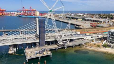
The newly-released vision for the replacement of the Fremantle Traffic Bridge is more about replanning than actual design.
The bridge presented is a bland, generic concrete structure that is already generating comment and controversy on social media and will continue to do so, with a life of its own.
For this reason, this Opinion Piece focuses on the changes from the ‘vision’ the Fremantle community thought had been agreed, which have all the elements of the good, the bad and the ugly.
The good
Let’s start with the good then work our way down into the swamps of the bad and the ugly.
Heritage
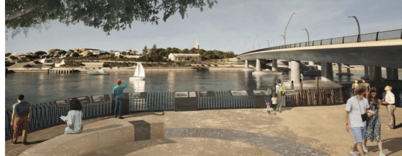
A dedicated heritage interpretation installation close to remnant piles of the current traffic bridge (right of picture) and the two earlier bridges (can’t be seen in this pic, but they’re down at water level).
Not-so-good is the fact that Main Roads, on its project webpage, doesn’t show this picture and only reports that “we are currently exploring ways to make a 3D digital capture of the entire [heritage] bridge and its surrounds readily available to the community, and for generations to come”.
Walking for Pleasure
The addition of a pedestrian path on the eastern side of the bridge was a key outcome of the 2021 forums. This is particularly important for North Fremantle residents (the majority) who live east of Queen Victoria Street.
Making the path 3-metres wide makes it a ‘comfortable’ space (apart from the traffic noise), for sauntering or even sitting, not simply a means of getting across the river.
Stirling Bridge
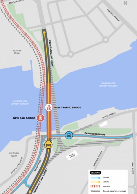
The very indirect access from Canning Highway to the new traffic bridge, which has echoes of freeway interchange design, will encourage drivers from the east to cross the river via the Stirling Bridge rather than the Fremantle Bridge. Whilst the east to north turning movements at the current old bridge are not huge, any reduction in traffic cutting the George Street centre of East Fremantle off from the river is to be welcomed.
However, the same effect could be achieved by the simple means of not allowing right turns from Canning Highway onto the Fremantle Bridge.
Given the existing traffic pressures on the Stirling/Canning Highway intersection, however, this might well require modification to the intersection layout and its traffic signals, to accommodate additional turning movements. Has the cost of this been factored into the project?
The Bad
Heritage
There is no indication of any bridge heritage on the southern bank of the river – notwithstanding the stated ‘opportunities’ for ‘use of existing timber pylons in the current traffic bridge in landscaping, heritage interpretation and community connection in front of the existing Naval Store’.

Compare this with the Mandurah bridge replacement where ‘remnant’ (albeit recreated) piles are visible on both sides, thus emphasising the ‘river crossing’ story. A similar approach here could provide boardwalk access above the river for fishers and visitors.
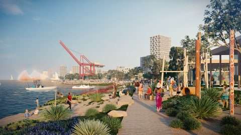
Parkland and the River
The City of Fremantle has lauded “new parkland stretching down from Cantonment Hill and the Naval Store towards the river”, whilst ignoring the loss of existing greenspace by the river there and the fact that this replacement (not new) parkland will be cut off from the river by 15,000+ vehicles a day – that’s the existing Beach Street traffic plus most of the Canning Highway traffic.
There is more bitumen and concrete and less greenspace with the new proposal than there is now – yes, it needs improvement (tidying up and making more accessible) but it doesn’t require Canning Highway’s shifting to achieve that.


It is more than somewhat ironic that the parkland lost is precisely where Moombaki, the Nyoongar storytelling project with a choreographed drone light show, was so successful at the 2021 Fremantle Biennale.
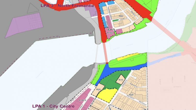
Losing Open Space Reserve
The whole of the area required for diverting Canning Highway is currently zoned ‘Open Space Reserve’ in Local Planning Scheme 4 (shown in green, below). Whilst most of this has not been well-managed, it is a valuable space that should not be given away lightly, even with part of the existing road reserve (blue) in exchange. It would need to be rezoned before any road works relating the Canning Highway deviation could be undertaken.
Look But Don’t Touch
The diversion of Canning Highway, with a path occupying the whole space between the road and the water’s edge, precludes any direct relationship between people and the water. No fishers – it isn’t a congenial environment and could be dangerous to cyclists and pedestrians. No places to sit and watch the life of the river.
An ‘Entry’ for Fremantle?
Balancing the traffic on Queen Victoria and Beach Streets sounds like a good thing from a traffic point of view (unless you happen to run the BP service station on QV Street), but this makes it very difficult to have any sort of ‘entry statement’ for Fremantle, as a large proportion of vehicle occupants will miss it.
Traffic Transferring
10,000 vehicles a day from Queen Victoria Street (currently 31,000) to Beach Street (currently 6,000) might well improve the notional efficiency of the road system, but this is a classic case of ‘improving’ mobility rather than accessibility.
It will, in any case, lead to many more complicated traffic movements closer to the centre of Fremantle to sort out destinating vehicles from through traffic, all of which will have to recross Queen Victoria Street.
East Street
Faced with an almost dead halt and sharp lefthand turn taking them into an unfamiliar part of Fremantle, at least some car drivers will very soon look for more familiar or less difficult alternatives. East Street, providing direct access to High Street via a signalised intersection there, will be the prime candidate for many – certainly in preference to the congested Stirling Highway, with its preponderance of heavy trucks, and the ‘Devil’s Roundabout’ at its intersection with High Street.
East Street currently has about 3,000 vehicles a day, which is generally accepted as the upper limit for a residential street. Even a thousand or two additional vehicles a day will certainly be more than noticeable to the people who live along it.
East Street is a boundary road between Fremantle and East Fremantle. I wonder how the East Fremantle people feel about this?
Traffic Speeds
Removal of the Canning Highway/Queen Victoria Street junction would result in a 1-kilometre stretch of wide sweeping road with no traffic control or speed management. Whilst the curve towards Fremantle is consistent with the community’s preferences as expressed in the 2021 workshops and forums, this was always with the expectation of some interaction with Canning Highway.
One kilometre without the effective control of a signalised junction will lead to an increase in speeds both on the bridge and on Queen Victoria Street – at precisely the point where we should be encouraging drivers to slow on entry into the centre of Fremantle.
Victoria Quay
It has been suggested that realignment of Canning Highway is desirable for the success of future development of Victoria Quay. Apart from all the uncertainties that have long surrounded such development and continue to do so, is it likely to (or would we want it to) attract more people in cars than could reasonably access it via Beach Street and the existing Gate 3?
Cost
When the project was first announced, two years ago, the budget was $230 million. The budget is now said to be $280 million, an increase that might just accommodate cost-inflation.
The realignment of Canning Highway adds yet another substantial cost to the project. There has been nothing yet on the business case for the realignment, how much additional funding would be required or where the additional funding would come from.
And The Ugly
Traffic – taking an additional 11,000 vehicles a day down to the river foreshore – plus virtually forcing trucks from Victoria Quay (Gate 3) along the foreshore to East Street to access Canning Highway, doesn’t seem like a great way to activate the river.
So much bitumen and concrete down by the river definitely qualifies this for the ‘ugly’ category.
Disruption – diversion of Canning Highway cannot be undertaken until after completion of the new road bridge, as it requires demolition of the current bridge. However, the current bridge has to be kept partly-open to manage traffic during construction of the new bridge. This will require:
* Temporary connection of Canning Highway to the new bridge; or
* Temporary disconnection of Canning Highway from both Queen Victoria and Beach Streets (but where would the 11,000 vehicles a day go?); and
* An extended period of disruption to accommodate the sequential works.
On top of this, the extended period of disruption puts off the date at which we get the promised parkland, during which time this area will be totally out of bounds as a construction site. Why not just get on and landscape what is already there! Yes, I know about the Naval Stores – but that is a very small tail wagging a very large dog.
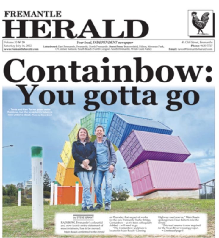
Removal of the Containbow – It is now clear why the containbow ‘has to go’, although strangely(?) it wasn’t mentioned at the time. Removal of a well-known and well-liked artwork in the name of unnecessary roadbuilding definitely fits my definition of ugly.
Fremantle for Cars? – I expected better of Freo than to have the Mayor make a statement like this: “The changes to the road network also have some major benefits in terms of keeping cars moving while minimising any impacts on pedestrian and cycle access“.
How about “…making access faster, safer and more convenient for pedestrians and cyclists while also improving access for car drivers and passengers”? Very disappointing to see the Freo Mayor relegate pedestrians and cyclists to externalities rather than a key part of improving Fremantle.
“Keeping cars moving” – can be a real negative. The proposal is a typical suburban one with no traffic control on the approach to Freo, between Tydeman Road and James Street, just a long sweeping curve that encourages drivers to go as fast as they can rather than a design that progressively slows drivers by making it clear they are entering an URBAN place.
Is this the ugliest of all?
While you’re here –
PLEASE HELP US TO GROW FREMANTLE SHIPPING NEWS
FSN is a reader-supported, volunteer-assisted online magazine all about Fremantle. Thanks for helping to keep FSN keeping on!
** Don’t forget to SUBSCRIBE to receive your free copy of The Weekly Edition of the Shipping News each Friday!

