This RADM is perhaps as far from a dull moment as you can get when we’re talking about local governments. Especially if you’re a planner, or a planning enthusiast! Lots of very impactful and exciting projects are now up and away, some the outcomes of years of hard work and community consultation. Not all are thrilled by this. Nonetheless, the items mark a of time of significant change for the greater Fremantle community as you’ll read below.
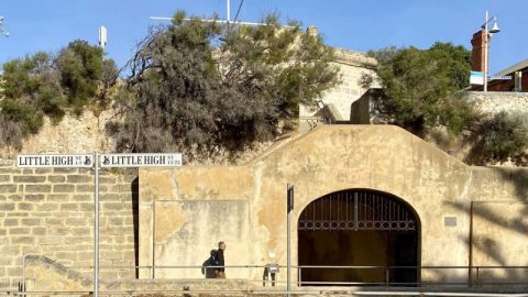
NOW THAT WE HAVE A QUORUM – SOUTH FREMANTLE HERITAGE AREA & HERITAGE POLICY REVIEW
This item was deferred from the 13 August 2025 meeting due to an unfortunate mix of eligible voting councillors being absent because of illness and the remaining being unable to vote due to personal interest in the South Fremantle Heritage Area (SFHA).
Former councillor and preeminent planning expert Prof Peter Newman spoke at Public Statement Time reflected on his past efforts to help protect heritage places from being bulldozed. In response to some comments made about the City’s approach to heritage not being meaningful in relation to the City Plan, he retorted “believe me, it’s very meaningful” to see what has happened since in the enhancement of heritage and regeneration of historic streetscapes, with the St Paul’s Church in Beaconsfield and his own 170-year-old cottage as great examples. Notwithstanding this, Mr Newman, Amanda Butterworth from planning consultancy Allerding & Associates, heritage consultant Eddie Marcus, and the landowner as well as a member of the Fremantle Society, advocated for the land containing a postwar Californian Bungalow next to the church at 166 Hampton Road remaining capable of development for a future potential affordable / community housing vision.
Objectors to the proposal spoke during public statement time this night to protest on the basis that they fear the formal recognition of their properties as “Contributory” (to the heritage values of SFHA) may hinder their ability to develop the properties.
Councillors responded sympathetically and agreed to excise 166 Hampton Road and 3 Trafford Street from the decision for consideration at the next annual review of the Heritage List.
Mayor Fitzhardinge spoke to the virtues of this project, praising the City’s effort over the last few years in getting to this point and as an outcome providing certainty for current and future landowners of heritage places by identifying contributory places upfront, whereas beforehand the heritage values may only be identified at the time of a development application being received by the City or in small increments at each annual Heritage List update.
Council unanimously resolved that:
1. In relation to the South Fremantle Heritage Area and as per Schedule 2 Regulations 8 and 9 of the Planning and Development (Local Planning Schemes) Regulations 2015:
a. Adopts the addition of properties to the Heritage List and Local Heritage Survey within Attachment 2;
b. Adopts the removal of properties from the Heritage List within Attachment 3;
c. Adopts the changes to the management categories of properties within Attachment 4;
d. Adopts the changes to the South Fremantle Heritage Area boundaries, changes to the Statement of Significance, and the addition of Contributory properties as shown in LPP 3.6.1 (Attachment 5);
e. Gives notice accordingly; and
f. Defer determination of 166 Hampton Road and 3 Trafford Street, as detailed in Attachment 2, to the next annual heritage review.
2. Adopts the following new or amended local planning policies and gives notice accordingly as per Schedule 2 Regulation 4 and 5 of the Planning and Development (Local Planning Schemes) Regulations 2015:
a. Draft LPP 3.6.1: Heritage Areas Listings (Attachment 5);
b. Amended LPP 1.6: Heritage Administration and Procedures (Attachment 6);
c. Amended LPP 1.7: Development Exempt from Approval Under LPS4 (Attachment 7);
d. Amended LPP 2.8: Fences (Attachment 8); and e. Amended LPP 3.6: Heritage-protected Places Built Form and Land Use (Attachment 9).
3. Revokes the following local planning policies and gives notice accordingly as per Schedule 2 Regulation 6 of the Planning and Development (Local Planning Schemes) Regulations 2015.
a. LPP 2.5: External Treatment of Buildings;
b. LPP 2.7: Archaeological Investigation as a Condition of Planning Approval;
c. LPP 2.20: Discretion to Vary Local Planning Scheme Site or Development Requirements for Heritage Purposes; and
d. LPP 3.7: “Hilton Garden Suburb Precinct” Heritage Area Local Planning Policy.
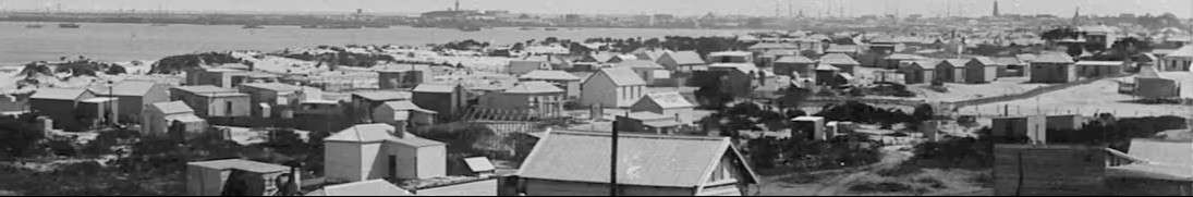
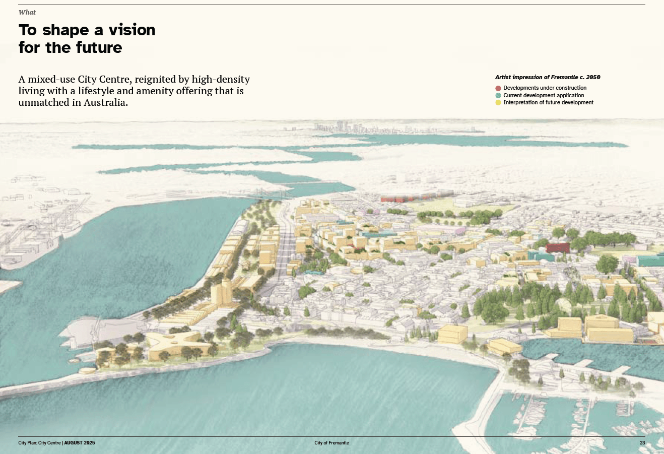
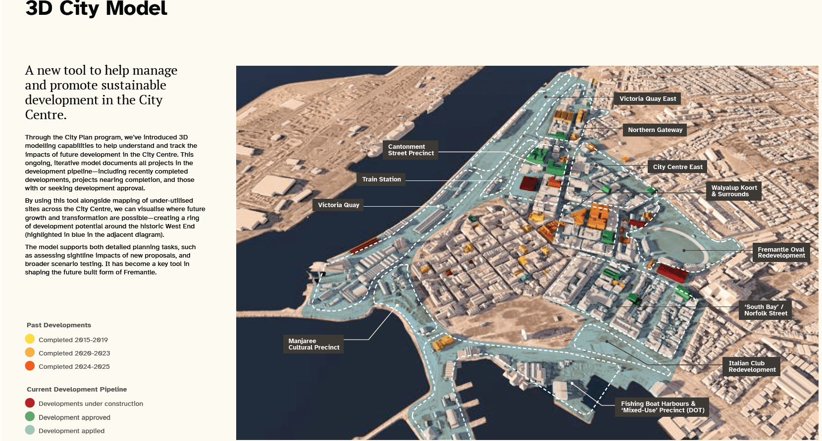
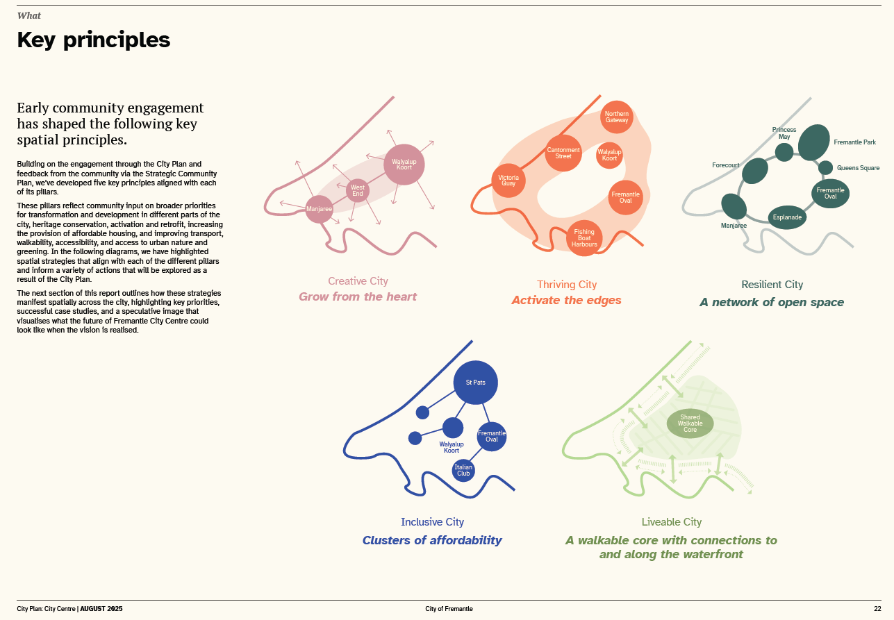
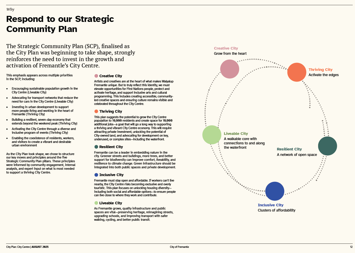
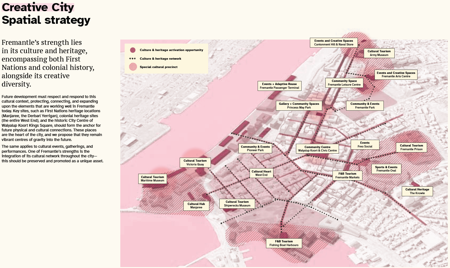
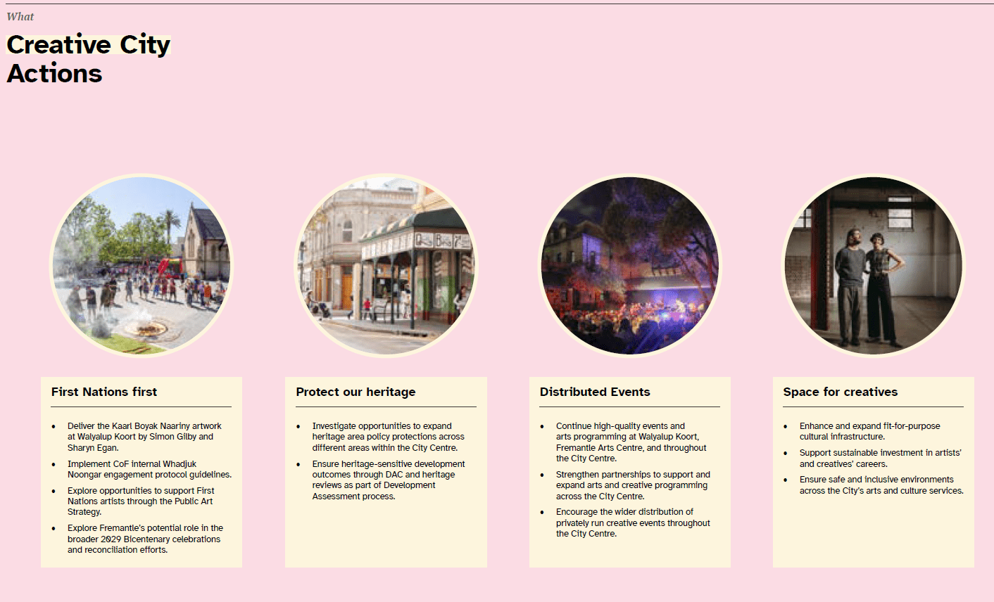
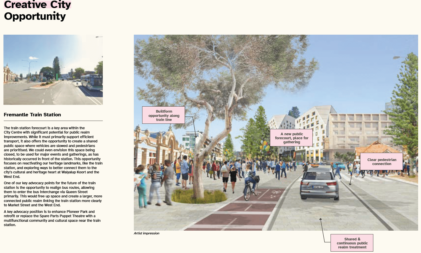
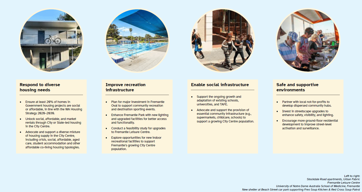
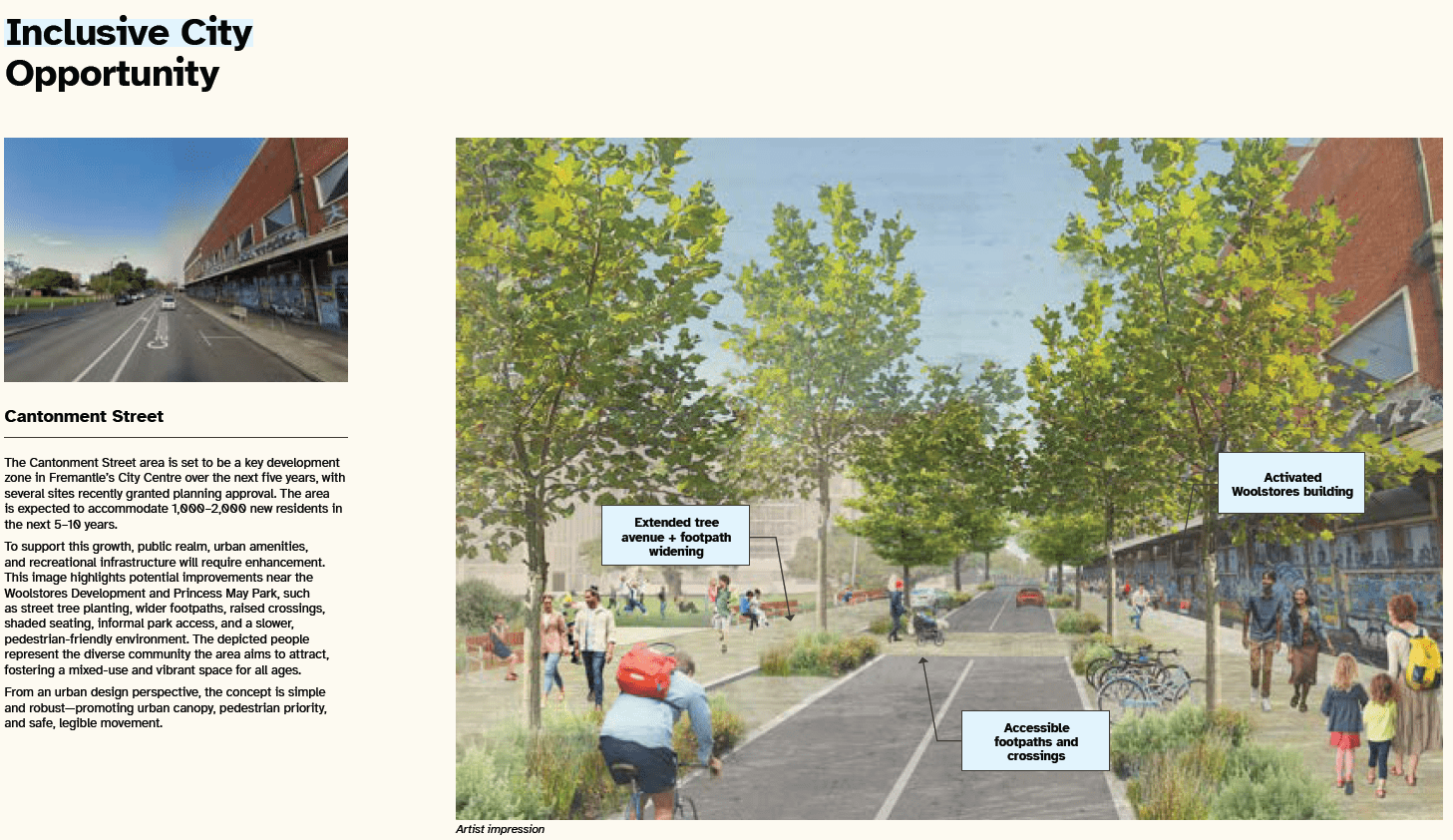
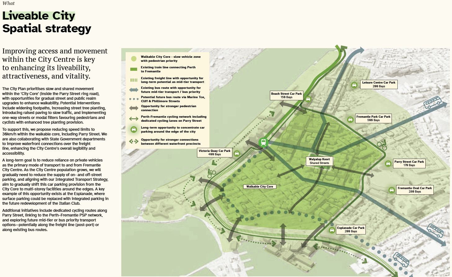
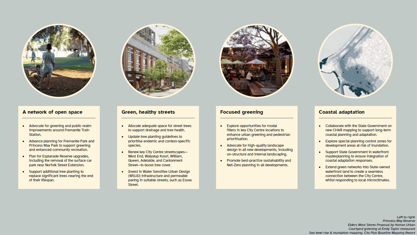
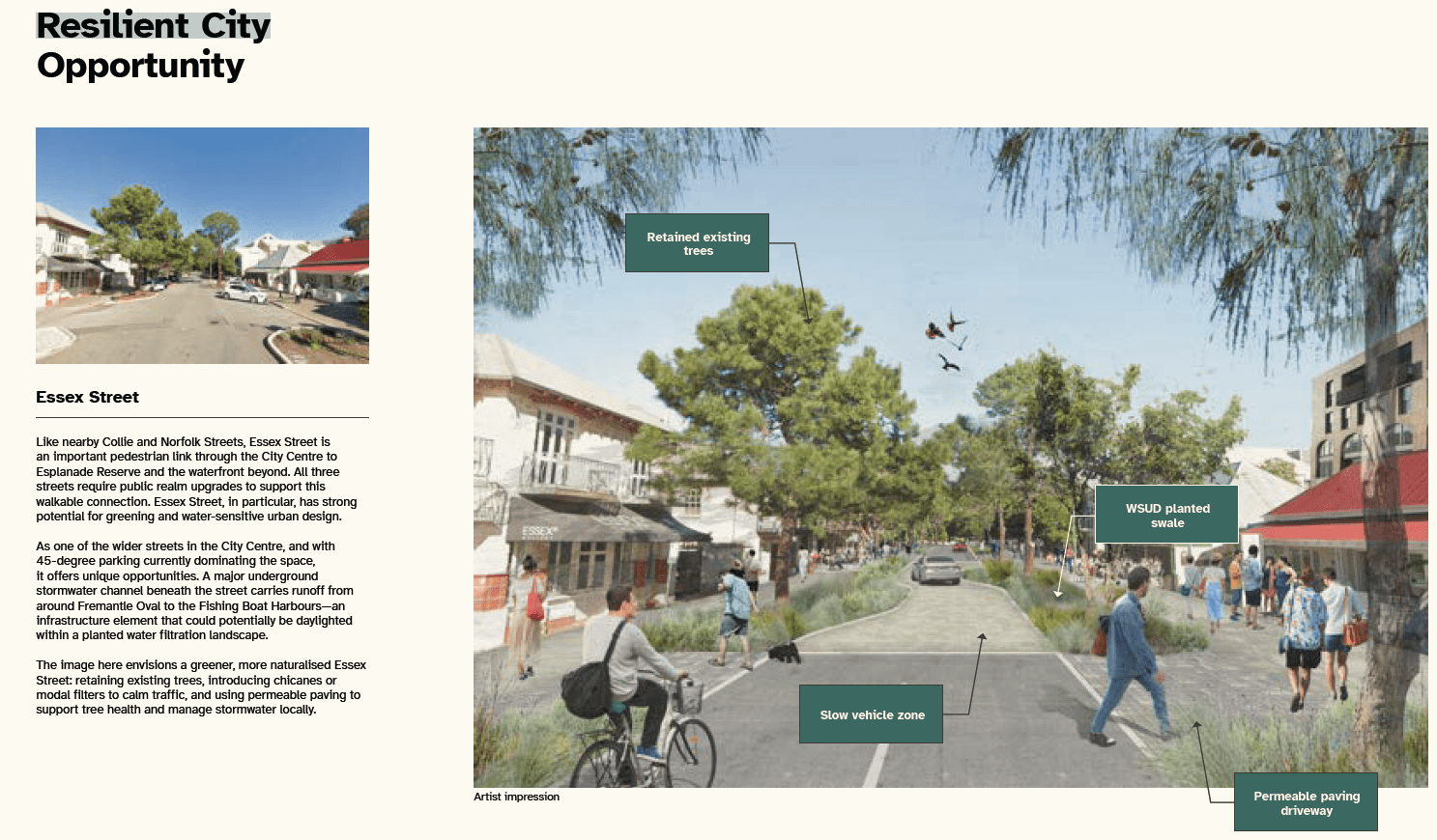
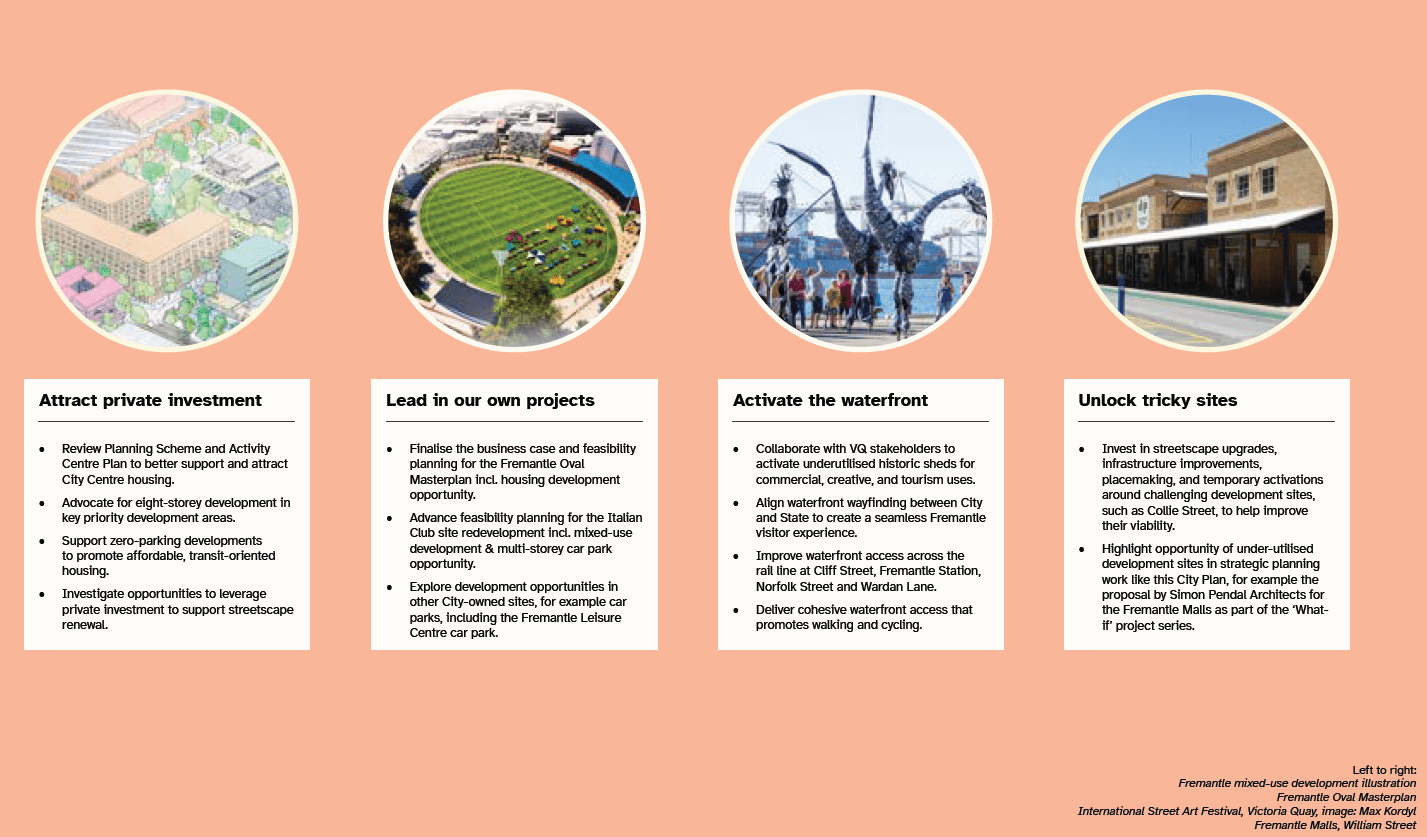
CITY PLAN: CITY CENTRE
Regular readers will likely remember this item when it was released for advertising at the 28 May 2025 OCM and our write up on the PS Artspace “What If” scenario exhibition.
As the officer report puts it, the City Plan is a “spatial companion to the Strategic Community Plan, [that] sets high-level direction on key issues including culture, heritage, development, affordability, greening, and transport.”
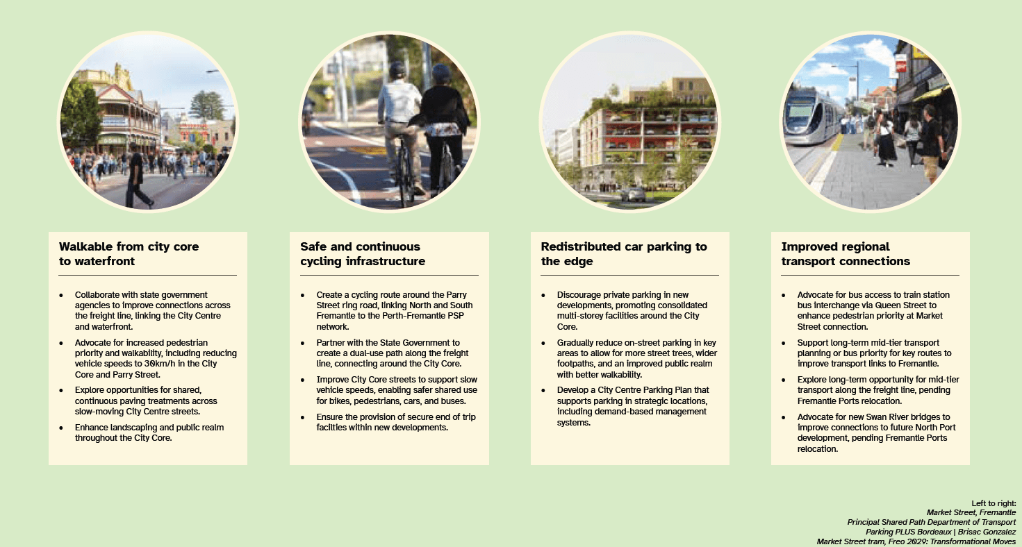
The City Plan provides a high level non-statutory approach to addressing “prioritised transformation of key areas within the City Centre”, housing affordability, heritage conservation and activation, improved transport systems, urban greening, streetscape revitalisation, and support for Fremantle’s unique cultural identity.
The City Centre: City Plan is structured generally as follows:
- Context and history
- Challenges
- Priorities
- Actions
- Case Studies
- Opportunities
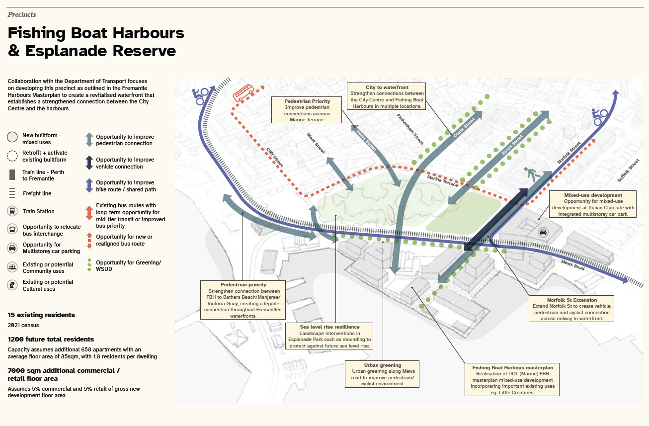
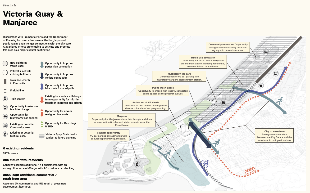
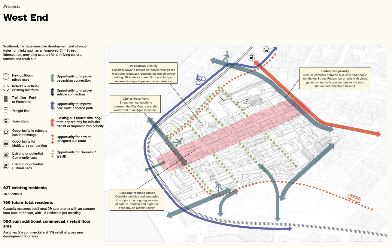
- Precincts – for future precinct plan development (a few are included in the gallery below)
- “What If” scenarios exploring hypothetical radical solutions in the West End
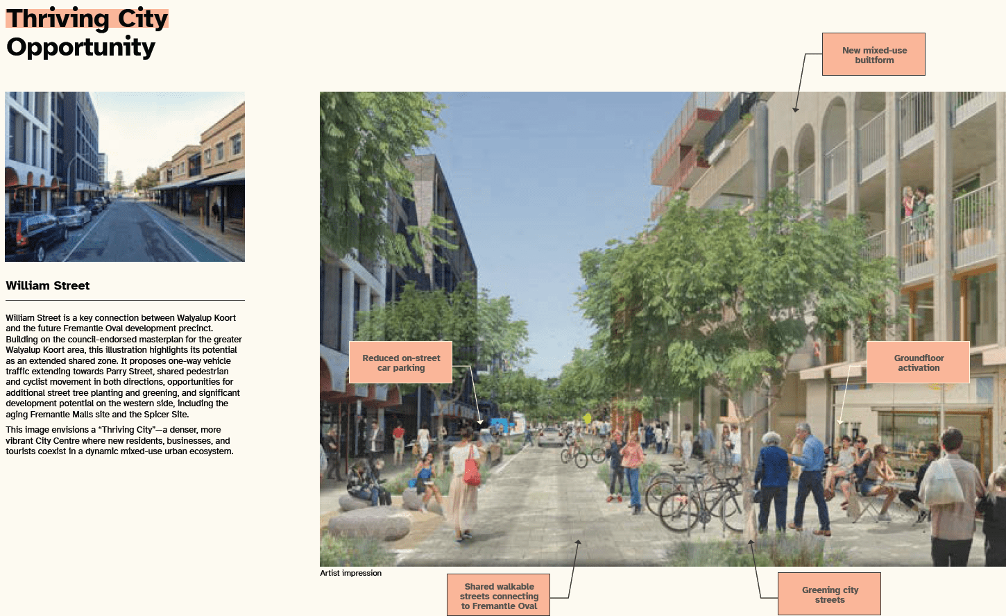
The gallery below showcases a handful of the content of the Plan but it is well worth taking a look at the entire work when you have the opportunity.
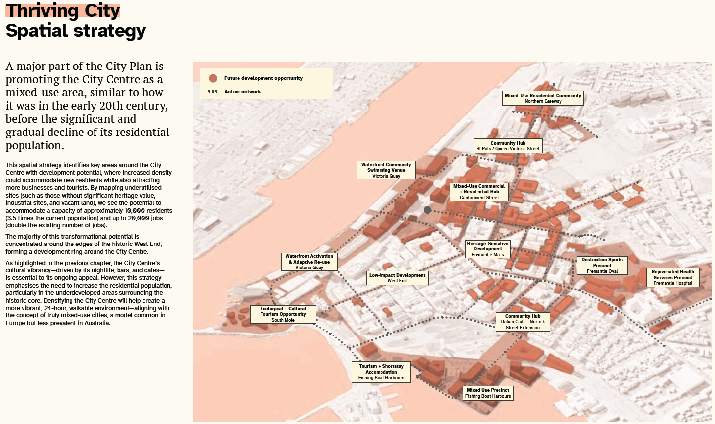
Mayor Fitzhardinge and Cr Van Dorssen praised the officers’ work in preparing the City Plan as a “fantastic piece of work” and expressed she is “really happy with the outcome”. She impressed the fact that the Plan as a non-statutory document does not disregard heritage nor supersede other planning instruments that govern heritage, in response to concerns raised by a community member during Public Statement Time. The Director of Planning, Place and Urban Development confirmed that this is a guiding document, there is no blanket eight storey height proportion under the City Plan, and that as usual height limits will be governed under the Local Planning Scheme which is currently being reviewed.
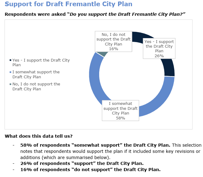
The project is the culmination of extensive engagement with planning and design professionals as well as the Fremantle community. Phase 1 of community engagement in mid-2024 attracted 1,350 participants The City used the IAP2 Public Participation Spectrum as usual to guide their engagement and used all tools at their disposal, including “focus groups, workshops, working groups [i.e. the City Plan Working Group comprised of elected members which met seven times to discuss the project since February 2024), surveys, online tools [including interactive mapping], face-to-face meetings, public events and exhibitions, as well as feedback and submission forms.” This distilled down to a draft Plan which was advertised via Phase 2 during June to July this year, via the exhibition we reported on during a rainy evening in June and the online MySay platform. This attracted 41 submissions, with 84% advertising of their support.
Those who did not support the Plan raised concerns including that they consider Fremantle’s urban environment is unsafe, that social housing is not well managed, they want the CAT bus free transit service back, future building heights are too high, Colonial heritage and later heritage is not sufficiently protected, and that recent urban renewal projects including Walyalup Koort were unsuccessful. All this and more are outlined in the Fremantle City Plan Engagement Report Phase 2 Appendix attached to the Council meeting agenda.
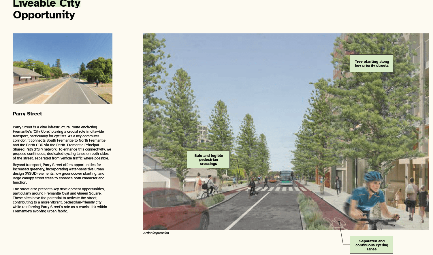
Meanwhile, the City has liaised with the Department of Planning, Lands and Heritage to ensure that the vision of the Plan does not conflict with the plans in Future Fremantle, which encapsulates the entirety of the Fremantle Ports land including Victoria Quay and South Quay. They also liaised with Fremantle Ports, the Public Transport Authority (PTA), and the Department of Transport and Major Infrastructure (DTMI) whom were overall supportive of the Plan and provided feedback to help inform it. One note of difference in opinions between the City and DTMI related to the City’s “preference for a primary commuter cycling route along Parry Street, rather than the freight/train line alignment proposed in DTMI’s Long Term Cycle Network”. Additionally, the City advocated for buses to access the train station and bus interchange via Queen Street instead of Marke Street in order to improve pedestrian safety and connectivity, which the PTA does not support as it would affect travel time and efficiency for them.
A few of the amendments to the City Plan arising from the latest engagement includes:
- Administrative updates such as dates, titles, Mayor’s foreword, and labelling;
- Updating population census details now that the 2025 figures are available;
- Adding outcomes from the Phase 2 engagement;
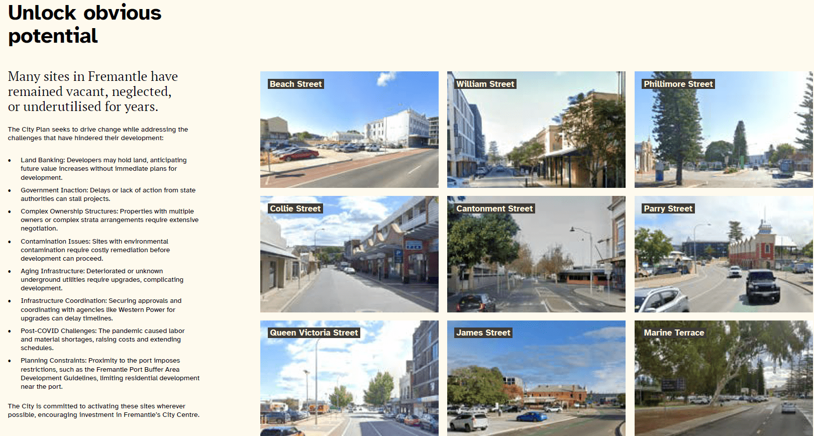
- Replacing a comment about rates with a note on leveraging private investment for streetscape renewal;
- Highlighting that vacant retail spaces will gradually fill with population growth in the Centre;
- Adding a note about support emerging decentralised infrastructure for EVs and solar power;
- Including text about unlocking “tricky sites” in relation to streetscape renewal;
- Adding expanded text on responding to diverse housing needs, emphasizing a wider mix of housing supply and listing a revised housing target so the 20% applies only to government housing projects/government land;
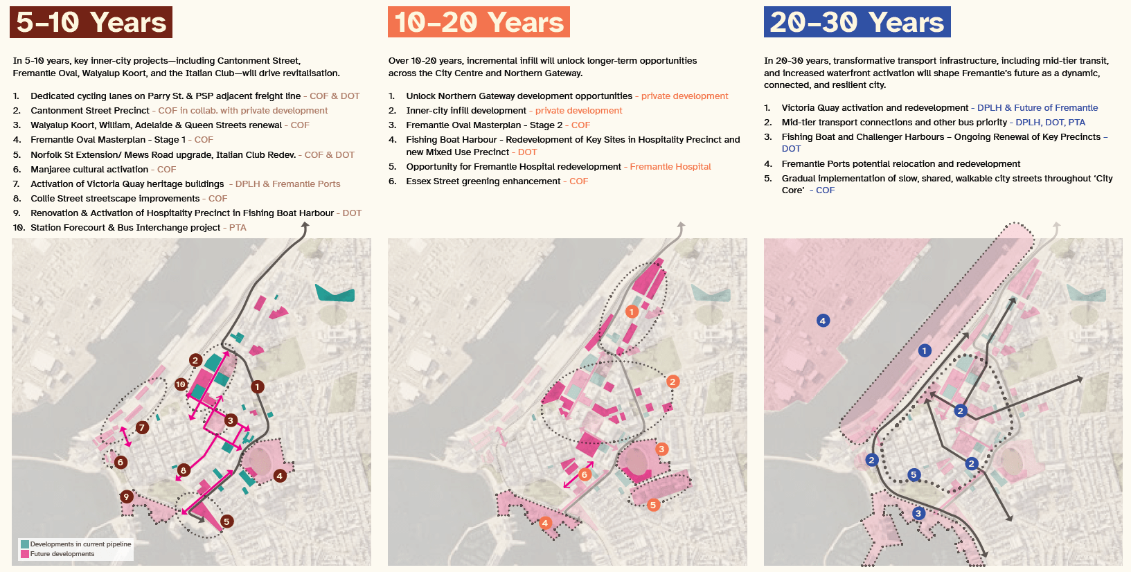
- Adding Point 10 (5–10 years) highlighting the station forecourt and bus interchange project;
- Adding a hatch over Victoria Quay to indicate it is subject to future precinct planning;
- Highlighting cultural, spatial, and pedestrian connections in various locations.
Cr Sullivan also praised the City Plan and the approach to it, noting that in the past for documents such as “Freo 2029: Transformational Moves” and Amendment 49 to the Local Planning Scheme No.4 there was pressure at the time for expedited changes to the City’s planning that wasn’t informed by as extensive a study as this one, so this marks an improvement that he is happier to see.
Council unanimously resolved that:
1. Receives the community engagement reports for Phase 1 and Phase 2 of the City Plan engagement process, as provided in Attachment 1 and Attachment 2.
2. Adopts the City Plan: City Centre as provided in Attachment 3; noting that the plan will guide the review of statutory planning instruments; public realm priorities; and advocacy for key city projects and initiatives.
LOCAL PLANNING STRATEGY ADOPTION
You might recall from the summary of the Review of Local Planning Scheme 4 item from the 13 August 2025 OCM that:
The City’s official Local Planning Strategy dates back to 9 July 2001 although it is unclear whether this was ever formally endorsed by the State Government. The new Strategy, however, is well on its way and will be headed back to Council after the election caretaker period [or so I thought! A small miracle that this one made it before the shutdown].
The City did previously present a report on LPS4 to the WAPC in February 2020 with a recommendation that the scheme be kept and updated. The WAPC said no. So here we are.
The officer report observes that the growing trend of performance-based decision making in planning reform reinforces the importance of instruments such as the Local Planning Strategy. Strategies provide the role of contextualising the provisions of statutory instruments such as Local Planning Schemes and provide guidance to ongoing challenges and updates to them. The Strategy is a roadmap, so to speak, that can help ensure that local planning is up to date and robust.
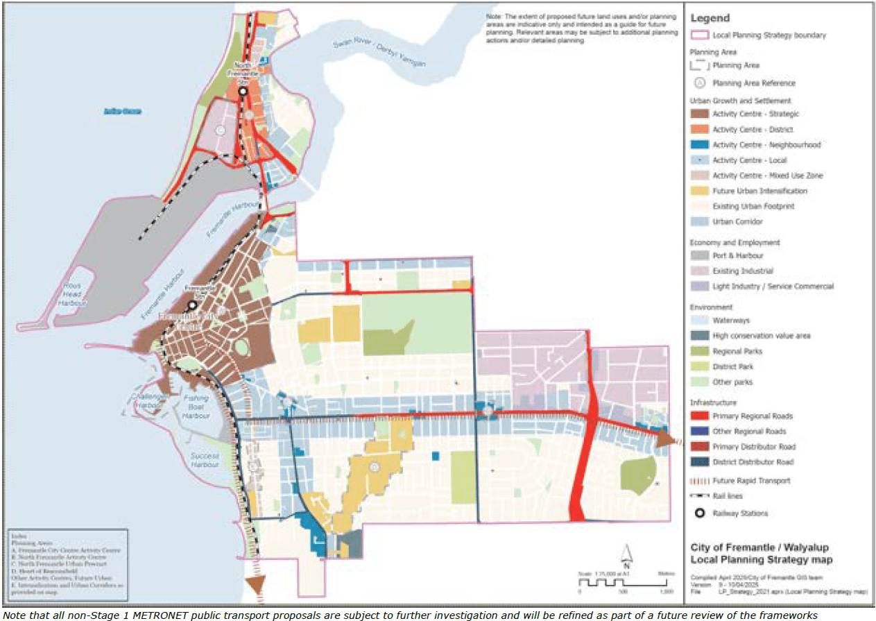
The objectives and aims of the Local Planning Strategy encompass the following:
- “A consolidated revitalised City Centre, ‘Perth’s second city’, a place of excitement, culture and core centre functions servicing a growing local, regional and international population.
- Population growth, housing diversity and planning for differing needs in well serviced locations focusing on development areas, transit corridor and contextually appropriate infill and varied housing typologies.
- Acknowledgement of the Aboriginal and European history of the place and conservation of built Heritage.
- The climate emergency, protection of the natural environment and sustainable urban and built form.
- Economic diversity including strengthening connections to south-west, and enhancing knowledge-based, blue and creative economies.
- Maintenance of a fine grain, highly walkable environment with high levels of amenity and quality public spaces, as well as improved connections and active transport throughout the region to allow ease of movement for people and goods.
- Review and provision of more efficient and effective utilisation of infrastructure to optimise community benefit.”
Accordingly, after extensive research the City prepared and referred the draft Local Planning Strategy to the 7 September 2022 Planning Committee meeting, where it was resolved that:
Council adopt the draft Local Planning Strategy provided in Attachment 1 and 2 for the purposes of public advertising and, in accordance with Regulations 12 of the Planning and Development (Local Planning Schemes) Regulations 2015, refer it to the Western Australian Planning Commission for preadvertising certification subject to the following amendment:
1. That Part 1 and Part 2 of the LPS is consistent around the economic (employment figures) associated with the current Port, being up to 8,000 jobs (at least 2,000 directly employed, and up to 6,000 indirect jobs.)
The City then sought permission from the Western Australian Planning Commission to advertise.
Three years of liaising with the Department of Planning, Lands and Heritage later to get it to a point where both entities can grudgingly agree, the heavily updated Strategy is arguably still true to the above objectives but features the following changes:
- “Refining the actions in Part 1 to better identify specific planning outcomes rather than broad objectives, some of which did not come under the purview of a planning strategy.
- Including additional background analysis in Part 2 on items such as population projections, dwelling numbers and retail needs;
- Incorporating aspects of the Future of Fremantle plan, the draft City Plan: City Centre, and the Strategic Community Plan 2024-2034, which were released during this process;
- Modifying the Strategy to fit the manner and form required by the WAPC.”
As a reminder, approval from the State Government is crucial as your Local Planning Strategy does not have effect without it, even when adopted by Council. That is tricky to do in an environment where all local governments are being pushed to adopt largely uniform changes to their Local Planning Strategies and Schemes despite their differing demographics, patterns of development and history, and environmental features.
Key actions stemming from the Local Planning Strategy include:
- Concentrating any density increases around important nodes, such as District, Neighbourhood, or Local Centres in close proximity to public transport and daily shopping.
- Review of retail potential and centres hierarchy in light of projected population growth and changes in the retail sector.
- Progressively update the City’s policy framework. [regular readers will note that this is already well underway]
- Maintain and refine its heritage protection framework. [again, also underway with project such as the South Fremantle Heritage Area Review, annual Heritage List update, policy review, and associated projects]
- Update structure plans (as required).
- Rationalise development zones once built out (as required). [already underway]
- Review Mixed Use zoning and controls.
- Placing parking requirements into a local planning policy and reviewing criteria
- Review development opportunities along the planned South Street and Cockburn rapid transit corridors if and when the state government confirms detailed planning, mode and funding commitment to these.
- Investigate local opportunities for ‘smart’ low impact infill in established neighbourhoods.
- Review success of inclusionary zoning / bonus provisions for incorporation of affordable and adaptable housing.
- Develop public realm and key open space area plans. [ongoing]
- Review the design principles and terminology in the scheme to better align with the subsequently adopted State Planning Policy 7.0, and expectations of design quality.
- Review of opportunities to ensure equitable development contributions toward infrastructure and public open space upgrades necessary to sustain population increase (taking into account the implications of these on development feasibility).
- Advocate for mid-tier transport and increased alternate modes of transportation along key urban corridors.” [ongoing, including via projects such as the City Centre: City Plan]
The City received permission to advertise the strategy on 25 June 2025. Advertising spanned over 21 days which overlapped with the City Centre: City Plan, concluding on 25 July 2025. Members of the public were invited to review the draft documents using the MySay platform, call, email, meet with planning officers, and attend a Talk to a Planner session. During that time, the City received just four responses, with two providing comments in respect to supporting vulnerable groups, disaggregating shopping centres to address activity centre catchment limitations, the future of the North Fremantle Urban Deferred Area currently being for an amendment to the Metropolitan Region Scheme and the Future Fremantle Project, and addressing rising sea levels. Another commenter was somewhat supportive, and the final fully supportive.
In response, the officer report advises that while the Strategy actions are limited to what the planning and development framework are capable of delivering (as opposed to other instruments), Table 2 and Opportunity 2 of the Strategy include various actions relating to vulnerable groups such as:
- undertaking a housing analysis to determine community needs,
- investigate innovative housing models that support affordability,
- investigate opportunities to incentivise housing diversity (particularly for affordable housing)
- [new action] advocate for affordable and social housing initiatives to be embedded into the state planning framework.
The report reiterates the need for a statewide approach to delivering social housing, lest developers resort to simply going elsewhere to boost returns in a location where social housing is not required by that local government.
Meanwhile, the City is also investigating partnering with organisations to utilise City-owned land for affordable development.
In respect to North Fremantle and coastal erosion, the officer recommended to leave this part of the Strategy unchanged as it was considered that sufficient consideration has also been provided for in the current wording and they do not wish to pre-empt the outcomes of the MRS Amendment and associated reporting on it.
As for activity centres in North Fremantle, while the officer observes that the City Plan: North Fremantle has examined the matter with the community, they assented to providing updated wording to consider a disaggregated model for centre dispersion subject to future decisions.
Notwithstanding the above, the Strategy has also been amended to incorporate the following:
- “Action (n) added to Table 1 to advocate for social and affordable housing initiatives to be embedded in the state planning framework.
- Action (o) added to Table 1 to create design guidance for alternate housing types that are currently absent from the planning framework, such as student housing, co-living, etc.
- Action (g) added to Table 2 to consider local foreshore assessments and CHRMAPs of estuaries to determine impact of estuary level rise on built and natural foreshore assets. Use as a basis to inform adaptive management measures and consideration of the potential to expand foreshore areas
- Action (h) in Table 2 calls for reviewing the Significant Tree and Vegetation Areas register and the Tree Protection planning policy for efficacy and investigating other options for tree protection and canopy increase.”
The University of Notre Dame provided comment in relation to its own planned expansion under the ND Masterplan, and various State Government agencies and neighbouring local governments also provided comment on the draft, which were noted and incorporated as amendments where necessary.
Council unanimously resolved without discussion (given the extent of discussion that has already taken place within elected member workshops internally and publicly at Council) to:
1. Endorse the Local Planning Strategy with modifications as set out in Attachment 1 in accordance with Regulation 14 of the Planning and Development (Local Planning Schemes) Regulations 2015.
2. Authorises the Mayor and Chief Executive Officer to sign the Local Planning Strategy, to be submitted to the Western Australian Planning Commission for consideration.
And now it’s off to the WAPC once again for approval. Hopefully it won’t take three years this time
MRS AMENDMENT NORTH FREMANTLE DEVELOPMENT PRECINCT
The City has been invited by the Western Australian Planning Commission (WAPC) to provide comment on the proposed Lifting of Urban Deferment for the North Fremantle Urban Precinct. This encompasses the former fuel terminal and lubricant depot, and former Standard Wool site next to the Future Fremantle boundary, immediately north of the freight rail line and south of Leighton Beach. Only a few warehouses are left within the precinct.
A great deal of the documentation associated with the proposal is confidential.
It is noted that the WAPC has not initiated the amendment to the Metropolitan Region Scheme to reflect this change just yet. If it does, despite the past assertion by the Department of Planning, Lands and Heritage, the City may not be invited once again to make formal comment.
“Does the State Government have a policy on transparency?” Queried Cr Sullivan innocently. “I’ll take that as rhetorical”, responded Mayor Fitzhardinge before swiftly moving on.
If the WAPC were to approve the lifting of the Urban Deferment and rezone the land to Urban in accordance with clause 23 of the Metropolitan Region Scheme, the City of Fremantle Local Planning Scheme would likely be concurrently amended to rezone the land to “Development”.
To give you more clarification on how the Urban Deferral works, before agreeing to finalise the conversion of the land to Urban, the WAPC (via the Planning guidelines – Lifting of urban or industrial deferment guidelines 2025) requires evidence that:
- “the land is capable of being provided with essential services and agreement has been reached between the developers and service providers with regard to the staging and financing of services;
- planning is sufficiently advanced to depict an acceptable overall design to guide future development;
- the proposed urban development represents a logical progression of development;
- regional requirements (such as regional roads, open space and public purposes) have been satisfied or provision made for them; and
- any constraints to urban development, including in relation to environmental, hazard and risk issues, can be satisfactorily addressed.”
In relation to this particular site, the following is required to make that final leap to Urban:
1. Finalisation or substantial progression of the Future of Fremantle project.
2. Confirmation of regional road and transport requirements in the locality.
3. Confirmation of coastal foreshore reserve requirements.
4. Consideration of the Fremantle Port Buffer.
The officer recommended that the City note the extensive work undertaken by the proponents to engage with the City and stakeholders over the last 18 months to urbanise the formerly industrial land at long last. These conversations are described as being constructive with a focus on aligning with future planning and policies for the North Fremantle area (including the North Fremantle City Plan). Despite this, they do not wish to fully support the proposal until the State Government undertakes further planning for the area, including:
a. Completion of the proposed North Fremantle Integrated Transport Design Study by Department of Planning Lands and Heritage;
b. Further consideration of the coastal foreshore reserve requirements, including documenting the impacts of the North Fremantle Integrated Transport Design Study on the coastal foreshore reserve area.
This includes the future of the Curtin Avenue and Stirling Highway connection, which has yet to be finalised, and connectivity to North Fremantle Train Station (which has been poised for potential relocation in the Future Fremantle planning). The applicants have endeavoured to make do with the uncertainty and developed a Movement Network Plan to consider the options.
- Surrounding Movement Network Change Stage 1 – Project Case (Immediate Term)
– Curtin Avenue extension and North Fremantle station relocation in accordance with FoF Vision document; and
– Active transport (shared paths) connections along Walter Place, Port Beach Road and the Curtin Avenue extension.
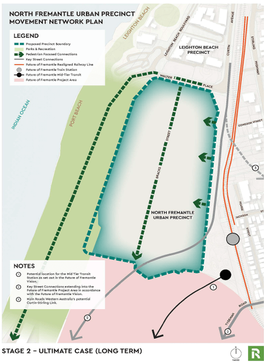
- Surrounding Movement Network Change Stage 2 – Ultimate Case (Long Term) – Outcomes consistent with FoF Vision as follows: o Curtin Avenue extension south of Tydeman Road to service North Quay;
– MRWA proposed Curtin-Stirling Link; o Addition of a mid-tier transport network; and
– Extension of shared path network.
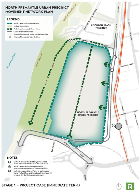
The City notes that the Stage 1 infrastructure is planned to be developed by 2031, which will support redevelopment and ongoing port operations. The generally supports the ‘immediate term’ proposal as it indicates downgrading of Port Beach Road beyond of Tydeman Road and “accommodates an extension of Curtin Avenue south to Tydeman Road, making use of the existing MRS reserve area (‘Primary Regional Roads’) for this purpose.”
Conversely, the Stage 2 proposal is not supported on the basis of the “Curtin – Stirling” link which would exacerbate connectivity issues to the coast and Queen Victoria Street centre for the North Fremantle community living east of Stirling Highway. It could also provide limited access to the Port and increase competition over use of Port Beach Road.
Subject to satisfaction of the requirements for Urban Deferral, the City supports the future Urban zoning of the land on the basis that:
- “The site is large enough for comprehensive urban development and is well located in proximity to the beach, train line (supporting transit-oriented development outcomes) and the North Fremantle Town centre.
- The State government has committed to moving the port’s container operations to a new harbour in Kwinana by 2040, relinquishing the need for industrial land uses in this area.
- The release of the Future of Fremantle (FoF) vision, demonstrating government commitment to a major redevelopment of the 260-hectare of the Fremantle Port Inner Harbour precinct, of which the North Fremantle Development.”
Cr Van Dorssen thanked the proponent’s representative from town planning firm Rowe Group whom spoke at Public Statement Time in defence of the proposal but reiterated that she considered there is still too much uncertainty and more work to be done in respect to future transport connections through the precinct and the City Plan for North Fremantle, which was echoed by Cr Williamson-Wong who also warned there will be 23-24 metres between future buildings and the reserve as it stands, which raises significant concerns about the adequacy of the reserve following coastal erosion anticipated over the next hundred years and beyond.
Cr Sullivan expressed his doubts about the spatial and coastal requirements for the precinct, noting that it seemed a stark coincidence that the edge of the coastal buffer in the CHRMAP aligns with the edge of the old railway reserve. “We should be determining what the long term assets for Port Beach are”, he argued, asserting that it is known that what is there currently (hardstand) is inadequate.
Speaking of inadequate, he spoke to the limited amount of time afforded to the councillors to properly consider the vast volume of documents that were indeed so large that some could not open the digital attachments properly. Regarding his amendments to the officer recommendation, Cr Sullivan expressed his sympathies for the developers and responding to the housing crisis, but the community and Council are “fed up” with the east-west disconnect between the coast and North Fremantle community due to the underutilised “triangle” of land bisecting them, particularly upon reflecting of the traffic bridge replacement project and Future Fremantle where regional transport was effectively blindsided. This sentiment was carried by Cr Lawver and Mayor Fitzhardinge as well, in addition to reiterating that the future transportation network needs to be resolved in North Fremantle before supporting full urbanisation.

Community member of the Leighton Action Coalition and industry expert, Paul Gamblin, spoke at Public Statement Time against the proposal out of concern of future projected coastal erosion from sea level rise, the amount of coastal engineering that could be required, and the public reserve width that may be required to help protect future communities living within the precinct, environment outcomes, and access for a “regional beach that serves over 100 suburbs”.
The coastal foreshore reserve itself was established at the time of the gazettal for the Urban Deferred rezoning back in 2024 (MRS Amendment 1400/41); this is not up for reconsideration as an outcome of this particular final stage but further confirmation of the coastal foreshore reserve requirements are.
On 11 December 2019, Council adopted a policy position of managed retreat as the preferred strategy in response to future projected coastal erosion at Port and Leighton Beach, to be implemented over an extended timeframe. In other words, not supporting development within the retreat area unless they are of a minor nature.
The applicant has responded to the coastal hazard risk by preparing their own Coastal Hazard Risk Management Adaption Plan (CHRMAP), which as summarised below argues:
- “The North Fremantle Urban Precinct avoids risks posed from coastal inundation and erosion hazards over the 100-year planning timeframe.
- Adequate space is available within the foreshore reserve (currently zoned parks and recreation under MRS amendment 1400/41,) to support managed retreat of publicly managed assets.
- Both points above are achieved assuming a managed retreat strategy, even if coastal protection is not implemented under the Future of Fremantle works.”
The applicant has supported the CHRMAP by preparing a North Fremantle Parks and Recreation Reservation Study (the P&R Study). As the report describes it, “the P&R Study investigates the suitability of the extent, size and purpose of the parks and recreation reservation within its context utilising three approaches as part of its review:
- Approach 1: Size and function of beach foreshores in WA.
- Approach 2: POS needs analysis for the local catchment.
- Approach 3: Future of Fremantle document and its relationship to the site.”
While the officer report notes that there has not yet been sufficient time for a full assessment of the CHRMAP given the limited time between receiving the documentation and having to bring it to Council for a decision, the P&R study makes reference to other major coastal reserves further north of the site which have different characteristics and do not account for the extent of the area within the reserve that would be occupied by Port Beach Road. Further, the question of biodiversity and conversation values and sufficient quantity of public open space reserve remains unanswered.
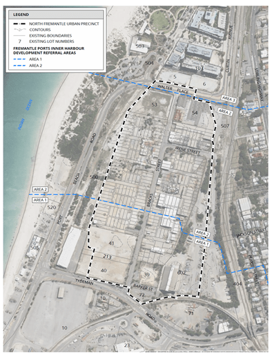
Additionally, the precinct falls within the Fremantle Port Development Referral (buffer) areas 1 and 2 and therefore must control development to account for the following risks:
a. Ingress of toxic gases in the event of an incident within the Port.
b. Shattering or flying glass as a consequence of an explosion within the Port.
c. Noise transmission emanating from the Port (attenuation in the order of 35dB(A) is required).
d. Odour.”
The applicant asserts that they have accounted for this and will address it via built form and land use controls in future precinct planning for the area. It will be required to be staged in conjunction with the planned relocation of Fremantle Port but can apparently coexist with it.
In summary, the City proposes the future urbanisation of the land but considers that there is still too much uncertainty associated with future transport networks and the foreshore reserve.
Council unanimously resolved to adopt an amended officer’s recommendation to include Cr Sullivan’s considerable additions that it:
1. Acknowledges the extensive work prepared by the applicant as part of the lifting request and the considered nature of their engagement with the City over the past 18 months and notes that the Council has had limited opportunity to review the information provided and, with that context, provides the following initial response, and reserve the right to provide a further detailed response to the matters listed in part 3 and 4.
2. Express deep concern to WAPC & Minister that the lifting of the Urban Deferred Zoning has not included transparent public consultation thus far, and encourages the WAPC to allow for submission to be made by the community ahead of a final decision.
3. Advises the WAPC that it does not support the Lifting of the Urban Deferment request for the North Fremantle Urban Precinct, until there is the resolution of the following matters:
a. Completion of the proposed North Fremantle Integrated Transport Design Study by DPLH that provides clear direction to transport planning for North Fremantle that also underpins planning capable of delivering an integrated urban plan for the North Fremantle Peninsula;
b. Further consideration of the coastal foreshore reserve requirements, including:
i. documenting the impacts of the North Fremantle Integrated Transport Design Study on the coastal foreshore reserve area; and
ii. assessment of, and long-term provision for, the additional recreational assets that are required to enable Port Beach to function as a regional coastal recreation node, in addition to but separate from the Leighton Node, noting that current recreation assets fall well short of accommodating existing and future needs;
iii. assessment of, and long-term provision for, the additional land needed to mitigate the existing spatial inadequacies around the Leighton node in providing suitable accessibility and function to that node;
iv. redressing the inconsistency in foreshore reserve width available to serve future generations towards the southern end of the Urban Precinct and to ensure the foreshore reserve provides adequate and continuous public access from Leighton through to Sandtracks Beach and the Future of Fremantle area;
4. Council requests the following concerns be addressed by the WAPC in consultation with the City of Fremantle and community as a precursor to Council support for the lifting of the Urban Deferment:
a. The community preference is for managed retreat in dealing with the long-term adaptation of the coast to accommodate climate change. There is special value placed on maintaining the long stretches of wide sandy beaches unimpeded by groynes or other intrusive coastal protection devices.
While it is acknowledged that some coastal protection devices will be inevitable as part of the Future of Fremantle project, these need to be restricted to the southern end as far as reasonably possible to ensure the character of Port Beach is not forever compromised by poor foreshore planning at this time. This requires the foreshore reserve adjacent to the Urban Precinct to be significantly wider than currently proposed.
b. It is noted that the foreshore reserve at Leighton Beach was planned at a time when the impacts of sea level rise were underestimated in the first iteration of SPP2.6. If the sea level rise coefficient currently used was applied to that node, the required foreshore reserve width would be closer to 200m compared to the 150m that was settled on.
The Port Beach Node has at least the same extent of recreational asset needs and is in a zone experiencing greater erosion compared to Leighton. Hence, it is demonstrably unacceptable that the proposed foreshore width at Port Beach would tapper to being narrower than the inadequate reserve width at the Leighton Node. The reserve width at the Urban Node must be significantly wider than at the Leighton Node and increasing in width towards the southern end where erosion is greater.
c. The existing reserve width at the Leighton Node has proved to be inadequate in providing for current recreational needs, especially in providing for the needs of the Leighton Surf Life Saving Club. The only opportunity to mitigate the inadequacies is for the WAPC to provide additional foreshore reserve width at the northern end of the Urban Node and in a manner that is functionally separate from the Port Beach node.
d. The proponent has only provided a coastal planning assessment based on existing assets. These existing Port Beach assets are clearly inadequate in serving current needs. The current node fails to provide space for parklands, recreational areas away from the beach, sustainable dunes to provide protection from the sea breezes, or adequate parking. Furthermore, there has been no assessment or the types of community and commercial assets needed to serve the long-term needs of the regional community, noting that 70% of beach users come from South of the River, or the significant population increase associated with the Future of Fremantle area. For example, there is clearly a regional demand for additional surf club facilities, cafes and the like, but no spatial assessment has been carried out to ensure the reserve width will accommodate such needs now or in the future. The requirements of SPP2.6 can not be satisfied by only seeking to accommodate the demonstrably inadequate existing assets.
e. The assessment of reserve width remaining at the 100-year planning (Fig 5.1 in the coastal assessment) highlights the inadequacy of the proposed foreshore reserve especially towards the southern end. The diagram highlights that the only way the reserve could be considered sustainable is to accept the need for radical coastal engineering devices that the community and Council have consistently opposed. A reliance on engineered solutions is inconsistent with SPP2.6 when there is ample opportunity to accommodate additional reserve width at this stage of planning.
f. The unique characteristics of the North Fremantle Peninsula are currently fragmented into several disconnected cells that fail to benefit from the tremendous lifestyle and commercial opportunities that the area can deliver. The further planning of individual transport corridors for each transport mode, all separated from each other and the urban cells around them, will only exacerbate the disconnect that already plagues the peninsula.
The proposed North Fremantle Integrated Transport Design Study provides an opportunity to address the disconnect by exploring how regional movement needs can be integrated with connected urban environments. In particular, the eastern edge of Urban Precinct, the land between it and the North Fremantle Town Centre, and the Town Centre itself must be considered through a single planning process to properly identify how the regional north-south transport activity can be integrated with local east-west movement and connectors.
g. The proponent’s assumption that their land can be developed independent of the potential upgrades to the surrounding movement network is a recipe to create another isolated and unintegrated cell of development. It is a proposal that seeks to ignore the need to complete the critical transport planning first. There is a genuine risk that the cell of development will essentially turn its back to the unresolved transport corridor rather than genuinely integrate with it.
h. The proponent offers only the opportunity for a 70’s style grade separated crossing solution between the Urban Precinct and the rest of North Fremantle. The Council expectation is for fully integrated east-west connectivity between the Town Centre and the Port Beach foreshore node. Until such time as the Transport Design Study is completed, it remains premature to consider urban development along the eastern edge of the Urban Precinct.
i. While it is noted that the proponent is not advocating for the Curtin-Stirling link which is proposed by MRWA, the Council notes its fundamental opposition to the concept. In the tight confines of the peninsula, the possibility of grade separated road flyovers is diametrically opposite to the integrated urban outcome that is needed. The only acceptable resolution of the north-south transport corridors is to investigate grade separated rail options, including the possibility of an elevated rail option.
It is imperative that such a fundamental change in the transport typology is understood prior to development. A grade separated rail network will also generate the possibility of east-west urban road connections that link between Stirling Highway and an extended Curtin Avenue, and by logical extension provide access into the Urban Precinct and connectivity to the Town Centre. Again, this highlights why the Transport Design Study needs to be completed first to inform how the Urban Precinct can better integrate with its surrounds.
j. The Future of Fremantle studies and those related to the new bridge sought to bypass meaningful consideration of how to resolve the regional transport network through the peninsula. That is why the North Fremantle Integrated Transport Design Study is now an essential prerequisite to further development.
However, the proponent relies on the initial transport concepts in the Future of Fremantle report to suggest their developments can progress independently of potential short and long-term changes in the transport networks. It is considered fundamentally premature to assume that the transport networks are resolved sufficiently to give the certainty needed once land is zoned Urban. This is particularly concerning at the southern end of the Urban Precinct in relation to both the alignment of Curtin Avenue, the rail corridor, and the ultimate location and number of future river crossings.
k. The triangle of government-controlled land to the east of the Urban Precinct continues to be treated in isolation of the Urban Precinct. It remains concerning, especially where that land widens to the south, that this land may continue to act as a barrier to east west movement rather than be seen as an opportunity for urban integration. This particularly relevant to the prospect for the North Fremantle Station to be relocated in a way that ensures it is encompassed by an urban station precinct. Likewise, the significant quantity of government land locked up in the triangle must be allowed to reach its full potential by being planned as part of an integrated urban precinct rather than being blighted as left-over unplanned land.
ENSURING A CULTURALLY VIBRANT CITY
Can a nice place to live also be an exciting one to visit? Can the West End have live music venues amongst private domiciles and other noise-sensitive premises? If that question was easy to answer, we wouldn’t be discussing it here.
FYI- a “noise-sensitive premise” means “places where people sleep, such as residences and hotels, but also includes other land uses such as hospitals, schools, childcare, aged care and public worship.”
The officer report sums up the conundrum:
“The City wants to support the ongoing sustainability of cultural venues, as they contribute to the desired vibrancy of the area. Equally so, increasing the base residential population of central Fremantle is a key objective to improving the overall sustainability of Fremantle in terms of environmental impact, economic development and a people-centred vibrancy throughout.”
This report follows on from the Notice of Motion passed at Council on 25 June 2025 and provides an update on the preliminary findings of investigations on how to balance noise and the right to quiet living.
The working group depicted to the issue has met three times since in July and stakeholders including hospitality venues participated in a workshop on 31 July 2025 involving a round table discussion on seven Draft Principles for noise management in the City.
Northbridge was examined as one of the relevant similar case studies on the issue which found:
- In 2019, the City of Perth and the State Government collaborated to map noise sources and investigate potential mitigation strategies.
- “Existing Noise Regulations measure noise from the noise-sensitive receiver. This means that if a new noise-sensitive development opens nearby, the permissible noise emitted is reduced. This results in a continual moving of goalposts for noise-emitting development whenever a new noise-sensitive development begins operating.
- Existing Noise Regulations do not adequately take into account low frequency sounds associated with music (generally at the 63Hz and 125Hz ranges).
- Constructing or retrofitting existing buildings to sufficiently cater for low frequency noises would be prohibitively expensive, requiring an enclosed balcony of a minimum depth to stop the noise (it is noted that, in addition to the expense, some of the recommended improvements would likely conflict with Fremantle requirements to retain heritage buildings).”
Meanwhile a common approach across Australia, originating in Brisbane, is to designate a Special Entertainment Precinct through their planning framework, which typically identifies a core and a frame/buffer area. Within these areas, buildings are regulated to cater for noise (both emitting and receiving). Critically, in such instances state-based Noise Regulations were modified to allow their local governments to establish noise levels based on local context and allow noise readings to be taken from a “set point (e.g., 3 metres from the building)” instead of the source of noise emissions. That allows the risk of “moving goalposts” arising from clustering of new noisy premises to be mitigated early on and addressed more fairly.
Despite such examples, no known movement has been made at State Government level to update the Environmental (Noise) Regulations 1997, the planning system to allow such an approach, or even the City of Perth’s own scheme amendment initiated in response to the 2019 study! And here we are.
The City developed seven draft principles to guide how it will tackle the matter, which have since been distilled down to five in response to stakeholder input in the workshops. Meanwhile, the City intends to continue updating its own policies to ameliorate where possible and to advocate to the State Government for a considered approach to the challenge.
Noise mapping is intended to be undertaken for the City Centre to allow for more accurate and rigorous review of potential and acceptable impact as land uses change and if changes to the planning framework ultimately occur (the report optimistically says ‘when’, and I say ‘if’!).
The report does take care to emphasise that the work the City does should also include socialising the idea of ‘agent of change’ to ensure that new venues are cognisant of the mixed use environment they are planning to occupy, and vice versa new noise sensitive developments are to be required to implement noise abatement design “rather than move in and then complain about the noise next door.”
Cr Lawver took a moment to thank City staff for all their hard work on this matter. Cr Sullivan also added that this is stage one, so to speak, and won’t be the only opportunity to contribute to it, but meanwhile he offered congratulations to all involved in working together successfully to establish the principles. These sentiments were supported by Mayor Fitzhardinge who observed the challenges ahead and the value of having solid noise mapping data to work with.
Much to ponder on next time we’re out for a drink, a laugh, or a dance at one of our favourites.
Council unanimously resolved that it:
1. Receives this report in response to the Notice of Motion C2506-20, passed at the Ordinary Meeting of Council held on 25 June 2025.
2. Approves the following key principles, to guide future work around managing and regulating acoustic amenity in the City:
• BALANCE: Local government decisions about noise should carefully weigh health, social, cultural, economic, environmental, and heritage impacts with the aims of
(a) protecting community wellbeing and heritage,
(b) increasing residents and visitors, and
(c) maintaining a vibrant, creative and multicultural arts and music friendly city.
• EVERYONE’S INVOLVED: All stakeholders should take reasonable and practical steps to reduce noise impacts (whether creating noise or affected by it) so they can better fit in with the neighbourhood and its usual noise levels.
• AGENT OF CHANGE: Anyone moving into or expanding in an area should understand the surroundings and take steps to fit in with what’s already there.
• BEING PRACTICAL: Actions and associated costs to manage or reduce noise (whether it’s coming from or affecting a place) should be practical and in proportion to how serious the potential health impacts or problems are.
• CITY LIFE: Everyone should understand that even if noise rules are followed and expert advice is used, some noise may still affect homes or other noise-sensitive places, and this reflects normal life in a vibrant City.
3. Request the Chief Executive Officer progress with the following actions:
a. Refinement of planning controls, to be undertaken as part of the Planning Framework Review over the next 12 months, including:
• Investigating the creation of ‘special areas’ within the city where elevated noise levels are acknowledged and accepted;
• Planning Policy development to guide future developments towards adequately dealing with mitigation of potential negative impact from noise;
• Move towards placing the onus on the ‘agent of change’ to make adjustments to mitigate noise issues, as well as develop clarity around identifying the ‘agent of change’.
b. Undertake baseline mapping of the existing noise profile of the City to assist with:
i. a more comprehensive understanding of the current situation; and
ii. to provide a more accurate acoustic context for specific sites so that better noise regulation/ management can be administered through the Development Approval process in the future.
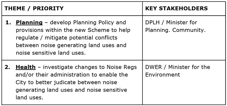
c. Undertake key advocacy activities in accordance with the following theme and priority:

4. Note that a report on the progress of the above actions will be brought back to Council within 12 months.
IN OTHER NEWS
Council also resolved to adopt the new Economic Development Strategy 2025-2030 (which I would have written about in detail here if I hadn’t run out of room), the Commercial Plan, and take on board the latest update on the Urban Forest Plan progress. The Procurement Policy also got an update, and the North Fremantle Associated Clubs lease agreement for Gil Fraser Reserve was approved after years of negotiations. Last but not least, a community member at Public Statement Time reminded Council that there has yet to be an AUKUS Public Forum, despite prevailing concerns.
Also, the next Council meeting on 10th September has been cancelled. Officers concluded that it would be more efficient to consolidate the relatively few reports anticipated for the month into a single meeting instead. No arguments here. Yours truly shall enjoy putting her feet up for a bit.
Now as I’ve mentioned a few times before, we are about to enter in the Caretaker Period from close of business on 4th September until after the Council election on 18October 2025. Make sure you’re enrolled to vote! There’s no democracy without participation.
To all candidates and current councillors seeking re-election, best of luck in your campaigning. The life of a councillor is far from an easy one and it’s often done around the demands of employment and / or parenthood. Yet many manage to make the time to listen to their locals and regularly attend public events. We have no favourites here at FSN but we admire your passion and tireless efforts to support our wonderful community.
During this time, it’s mostly business as usual but Council cannot make “significant decisions” that could potentially form a target for lobbying or otherwise likely polarise the decision makers. Items that have statutory timeframes attached to them, such as planning applications, will still be brought to Council as per usual, although it may not be quite the same without Joint Development Assessment Panel proposals being discussed at Council. We’ll have to watch the JDAP meetings in order to keep our finger on the pulse there.
See you here again in late September, or perhaps sooner out and about in the City Centre!
* By Gayle O’Leary. If you’d like to catch up on more by Gayle here on Fremantle Shipping News, look right here!
~~~~~~~~~~~~~~~~~~~~~~~~~~~~~~~~~~~~~~~~~~~
* If you’d like to COMMENT on this or any of our stories, don’t hesitate to email our Editor.
** WHILE YOU’RE HERE –
PLEASE HELP US TO GROW FREMANTLE SHIPPING NEWS
FSN is a reader-supported, volunteer-assisted online magazine all about Fremantle. Thanks for helping to keep FSN keeping on!
*** Don’t forget to SUBSCRIBE to receive your free copy of The Weekly Edition of the Shipping News each Friday!


